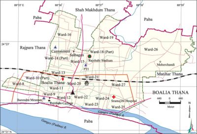
Boalia Thana
Boalia Thana (Rajshahi metropolitan) area 31.69 sq km, located in between 24°21' and 24°23' north latitudes and in between 88°28' and 88°38' east longitudes. It is bounded by paba upazila and shah makhdum thana on the north, padma river and Paba upazila on the south, matihar thana and Paba upazila on the east, rajpara thana and Paba upazila on the west.
Population Total 171252; male 90500, female 80752; Muslim 157940, Hindu 12839, Buddhist 329, Christian 38 and others 106.
Administration Boalia Thana was formed in 1979.
| Thana | ||||||||
| Ward and Union | Mahalla and Mouza | Population | Density (per sq km) | Literacy rate (%) | ||||
| Urban | Rural | Urban | Rural | |||||
| 16+3 (part) | 82 | 171252 | - | 5404 | 69.34 | - | ||
| Ward | ||||||||
| Ward | Area (sq km) | Population | Literacy rate (%) | |||||
| Male | Female | |||||||
| Ward No. 8 | 1.86 | 5837 | 5433 | 85.22 | ||||
| Ward No. 9 | 1.10 | 5662 | 4867 | 74.86 | ||||
| Ward No. 10 (part) | 0.30 | 2533 | 2431 | 73.26 | ||||
| Ward No. 11 | 0.57 | 4731 | 4543 | 66.63 | ||||
| Ward No. 12 | 1.94 | 5583 | 4252 | 77.79 | ||||
| Ward No. 13 | 2.24 | 4582 | 4219 | 77.31 | ||||
| Ward No. 14 (part) | 0.55 | 1689 | 1495 | 73.12 | ||||
| Ward No. 15 | 2.40 | 5384 | 5111 | 79.90 | ||||
| Ward No. 16 | 3.74 | 6575 | 5427 | 66.96 | ||||
| Ward No. 18 (part) | 0.11 | 678 | 591 | 53.03 | ||||
| Ward No. 19 | 3.12 | 4741 | 4136 | 65.62 | ||||
| Ward No. 20 | 4.83 | 6776 | 6007 | 61.25 | ||||
| Ward No. 21 | 1.34 | 6534 | 5991 | 52.42 | ||||
| Ward No. 22 | 0.82 | 4371 | 3717 | 73.34 | ||||
| Ward No. 23 | 1.44 | 4990 | 4457 | 66.36 | ||||
| Ward No. 24 | 1.10 | 3738 | 3562 | 79.47 | ||||
| Ward No. 25 | 1.16 | 4129 | 3828 | 67.35 | ||||
| Ward No. 26 | 1.95 | 6295 | 5489 | 54.38 | ||||
| Ward No. 27 | 1.12 | 5672 | 5196 | 69.13 | ||||
Source Bangladesh Population Census 2001, Bangladesh Bureau of Statistics.

Archaeological heritage and relics Tomb of Hazrat Shah Makhdum (1645), Bara Kuthi (eighteenth century).
Religious institutions Mosque 45, temple 7, church 1 and tomb 1. Noted religious institutions: Shaheb Bazar Bara Mosque, tomb of Hazrat Shah Makdum (R), Hatem Kha Bara Mosque, Malopara Shahi Mosque, Dharmasava Mandir (Miapara), Kalitala Mandir (Fudkipara), Kali Mandir (Saheb Bazar), Christian Missionaries Church.
Literacy rate and educational institutions Average literacy 69.34%; male 75.39%, female 66.43%. Noted educational institutions: Rajshahi University College (1873), Rajshahi Medical College (1949), Rajshahi Collegiate School (1828), PN Girls' High School (1886).
Newspapers and periodicals Daily: Dainik Barta, Dainik Sonali Sangbad, Dainik Sonar Desh, Dainik Prothom Probhat, Dainik Lal Golap, Dainik Upachar, Dainik Padmar Bani, Daily Sun-Shin; Weekly: Weekly Dunia, Weekly Rajshahi Barta, Weekly Ganakhabar, Weekly Dharani; Monthly Uttar Janapath; Defunct papers- Weekly Hindu Ranjika, Weekly Rajshahi Sangbad, Weekly Gayanangkur, Monthly Shikshka Parichaya.
Cultural organisations Club 60, library 10, museum 1, theatre stage 1, theatre group 9, cinema hall 4, women's organisation 20, playground 10.
Main sources of income Agriculture 3.33%, non-agircultural labourer 2.12%, commerce 28.14%, transport and communication 9.70%, service 32.73%, construction 3.74%, religious service 0.15%, rent and remittance 2.11% and others 17.98%.
Ownership of agricultural land Landowner 34.25%, landless 65.75%.
Main crops Paddy, jute, sugarcane, vegetables.
Extinct or nearly extinct crops Sesame, kaun, linseed, arahar.
Main fruits Mango, black berry, jackfruit, litchi, banana.
Extinct or nearly extinct traditional transport Palanquin, bullock cart and horse carriage.
Noted manufactories Silk industry, welding factory.
Cottage industries Silk industry.
Hats, bazars and fairs Hats and bazars are 11, fairs 1, most noted of which are Saheb Bazar, Shal Bagan, New Market and Rath Mela (Kumar Para).
Main exports Silk cloth, cotton cloth.
Access to electricity All the wards of the thana are under electrification net-work; however, 84.01% dwelling households have access to electricity.
Sources of drinking water Tube-well 73.34%, pond 0.11%, tap 25.21% and others 1.34%.
Sanitation 86.52% of dwelling households of the upazila use sanitary latrines and 11.50% of dwelling households use non-sanitary latrines; 1.98% of households do not have latrine facilities.
Health centres Government hospital 3, health and family planning centre 17, diabetic hospital 1, heart foundation hospital 1, TB hospital 1, TB clinic 1, eye hospital 1, veterinary hospital 1.
NGO activities brac, asa, CARE, caritas, thengamara mahila sabuj sangha. [Sufia Parveen]
References Bangladesh Population Census 2001, Bangladesh Bureau of Statistics.
