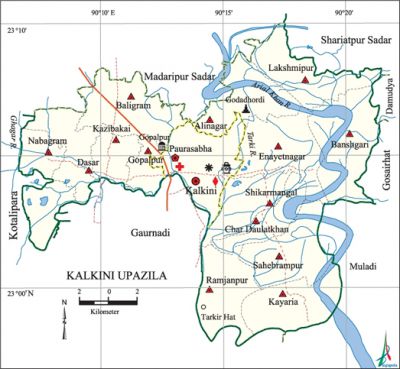
Kalkini Upazila
Kalkini Upazila (madaripur district) area 204.28 sq km, located in between 23°00' and 23°10' north latitudes and in between 90°06' and 90°21' east longitudes. It is bounded by madaripur sadar and shariatpur sadar upazilas on the north, gaurnadi upazilas on the south, gosairhat, muladi and damudya upazilas on the east, kotalipara and Gaurnadi upazilas on the west.
Population Total 201764; male 97713, female 104051; Muslim 189475, Hindu 12269 and Christian 20.
Water bodies Main rivers: arial khan, Ghagar and Tarki.
Administration Kalkini Thana was formed in 1909 and it was turned into an upazila on 1 February 1984.
| Upazila | ||||||||
| Municipality | Union | Mouza | Village | Population | Density (per sq km) | Literacy rate (%) | ||
| Urban | Rural | Urban | Rural | |||||
| 1 | 9 | 73 | 115 | 41608 | 160156 | 988 | 55.3 | 46.3 |
| Municipality | ||||||||
|
Area (sq km) |
Ward |
Mahalla |
Population |
Density (per sq km) |
Literacy rate (%) | |||
| 27.79 | 9 | 38 | 41608 | 1497 | 55.3 | |||
| Union | ||||
| Name of union and GO code | Area (acre) | Population | Literacy rate (%) | |
| Male | Female | |||
| Alinagar 11 | 4940 | 7271 | 7817 | 38.5 |
| Enayetnagar 37 | 5785 | 12350 | 12766 | 40.7 |
| Kayaria 56 | 5275 | 7875 | 8573 | 53.5 |
| Char Daulatkhan 25 | 3242 | 5718 | 6071 | 41.0 |
| Banshgari 18 | 6435 | 10812 | 11481 | 39.6 |
| Ramjanpur 82 | 4817 | 8784 | 9566 | 52.2 |
| Lakshmipur 69 | 4926 | 9924 | 10281 | 36.5 |
| Shikarmangal 94 | 2525 | 5347 | 5842 | 50.4 |
| Sahebrampur 88 | 5668 | 9281 | 10397 | 55.6 |
Source Bangladesh Population Census 2011, Bangladesh Bureau of Statistics.

Archaeological heritage and relics Three domed Mosque of Miabari at Gopalpur (1869); Godadhardi Shiva Mandir at Alinagar, Durga Mandir, Pancha-Ratna Mandir at Char Fatehpur (1924), Senapati Dighi (Mughal period).
War of Liberation The Pak army conducted heavy plundering and genocide in different villages of the upazila and also set many houses of the upazila on fire. Freedom fighters had many encounters with the Pak army in the upazila including at Sauder Khalpar, Pinglakathi, Karnapara, Kalkini Thakurbari, Durghata, Palardi, Jailar Char and Hoglapatia.
For details: see কালকিনি উপজেলা, বাংলাদেশ মুক্তিযুদ্ধ জ্ঞানকোষ (Encyclopedia of Bangladesh War of Liberation), বাংলাদেশ এশিয়াটিক সোসাইটি, ঢাকা ২০২০, খণ্ড ২।
Religious institutions Mosque 831, temple 7.
Literacy rate and educational institutions Average literacy 46.3%; male 47.5%, female 45.1%. Noted educational institutions: Sahebrampur Kabi Nazrul Islam College (1972), Kalkini Sayed Abul Hossain College (1972), Shashikar Shahid Smriti College (1973), Sheikh Hasina Academy and Womens College (1995), Kalinagar High School (1904), Mahishmari Girls' High School (1918), Bir Mohan High School (1919), Nabagram High School (1943), Shashikar High School (1943), Kalkini Pilot High School (1946), Sahebrampur Multilateral High School (1946), Khaser Hat High School (1960), Samitir Hat' High School (1964), Gopalpur High School (1970), Snanghata High School (1970), Darsana High School (1973), Shashikar Girls' High School (1982).
Newspapers and periodicals Defunct: Balaranjika (1863).
Cultural organisations Library 6, club 60,' sport club 4, women organisation 3, cinema hall 3.
Main sources of income Agriculture 70.23%, non-agricultural labourer 2.78%, industry 0.48%, commerce 9.80%, transport and communication 1.49%, service 7.12%, construction 1.50%, religious service 0.27%, rent and remittance 1% and others 5.33%.
Ownership of agricultural land Landowner 75.11%, landless 24.89%; agricultural landowner: urban 63.32% and rural 77.10%.
Main crops Paddy, jute, sugarcane, mustard, pulse, wheat, sweet potato.
Extinct or nearly extinct crops Betel leaf, water-melon, bangi.
Main fruits Mango, jackfruit, papaya, coconut, banana, date.
Fisheries, dairies and poultries This upazila has a number of fisheries, dairies and poultries.
Communication facilities Pucca road 203 km, semi-pucca road 34 km, mud road 1002 km; waterway 120 km.
Extinct or nearly extinct traditional transport Palanquin, horse carriage.
Cottage industries Blacksmith, potteries, mat works, wood works, embroidery, cane works, date molasses workshop.
Hats, bazars and fairs Kalkini Hat, Maidan Hat, Sahebrampur Hat, Khaser Hat, Phasiatala Hat, Lakshmipur Hat, Jurgaon Hat, Mia Hat, Shashikar Hat, Dasar Bazar, Shashikar Mela (Chhiabhangar Dashohara Mela) and Baishakhi Mela are notable.
Main exports Jute, jute goods, date and sugarcane molasses.
Access to electricity All the wards and unions of the upazila are under rural electrification net-work. However 56.4% of the dwelling households have access to electricity.
Sources of drinking water Tube-well 95.4%, tap 0.9% and others 3.7%. The presence of intolerable level of arsenic has been detected in shallow tube-well water of the upazila.
Sanitation 78.3% of dwelling households of the upazila use sanitary latrines and 20.4% of dwelling households use non-sanitary latrines; 1.3% of households do not have latrine facilities.
Health centres Hospital 1, union family planning centre 10, clinic 2.
NGO activities Operationally important NGOs are brac, proshika, Swanirvar Bangladesh. [Rashimul Haq]
References Bangladesh Population Census 2001 and 2011, Bangladesh Bureau of Statistics; Field report of Kalkini Upazila 2007.
