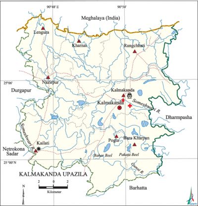
Kalmakanda Upazila
Kalmakanda Upazila (netrokona district) area 376.22 sq km, located in between 24°56' and 25°11' north latitudes and in between 90°44' and 90'58' east longitudes. It is bounded by Meghalaya state of India on the north, barhatta and netrokona SADAR upazilas on the south, dharmapasha upazila on the east, durgapur (netrokona) upazila on the west.
Population Total 271912; male 134896, female 137016; Muslim 232423, Hindu 30390, Buddhist 15, Christian 8607 and others 477. Indigenous communities such as garo, hajong, Hodi and Banai belong to this upazila.
Water bodies Main rivers: Someshwari, Gunai; Pakata Beel and Bahar Beel are notable.
Administration Kalmakanda Thana was formed in 1941 and it was turned into an upazila in 1983.
| Upazila | ||||||||
| Municipality | Union | Mouza | Village | Population | Density (per sq km) | Literacy rate (%) | ||
| Urban | Rural | Urban | Rural | |||||
| - | 8 | 179 | 347 | 14383 | 257529 | 723 | 54.8 | 35.5 |
| Upazila Town | ||||
|
Area (sq km) |
Mouza |
Population |
Density (per sq km) |
Literacy rate (%) |
| 8.37 | 2 | 14383 | 1718 | 54.8 |
| Union | ||||
| Name of union and GO code | Area (acre) | Population | Literacy rate (%) | |
| Male | Female | |||
| Kalmakanda 35 | 15532 | 24006 | 23846 | 42.8 |
| Kailati 23 | 13199 | 21255 | 21052 | 34.2 |
| Kharnai 47 | 10343 | 13230 | 13567 | 35.0 |
| Nazirpur 71 | 11293 | 18895 | 19335 | 36.7 |
| Pogla 83 | 10918 | 16141 | 16442 | 36.9 |
| Bara Kharpan 11 | 9131 | 9825 | 9993 | 35.1 |
| Rangchhati 95 | 14025 | 20217 | 21146 | 29.7 |
| Lengura 59 | 8526 | 11327 | 11635 | 41.8 |
Source Bangladesh Population Census 2011, Bangladesh Bureau of Statistics.
Archaeological heritage and relics Tomb of Monai Shah at village Battala.
War of Liberation A direct encounter was held between the freedom fighters and the Pak army at the junction of three roads in Nazirpur union on 26 July 1971 in which 7 freedom fighters were killed.
For details: see কমলাকান্দা উপজেলা, বাংলাদেশ মুক্তিযুদ্ধ জ্ঞানকোষ (Encyclopedia of Bangladesh War of Liberation), বাংলাদেশ এশিয়াটিক সোসাইটি, ঢাকা ২০২০, খণ্ড ২।

Literacy rate and educational institutions Average literacy 36.6%; male 37.9%, female 35.3%. Noted educational institutions: Kalmakanda Pilot High School (1942), Kalmakanda Girls' High School, Lengura High School, Rangchhati High School.
Cultural organisations Club 22, library 1, cinema hall 2, playground 6.
Tourist spots Tombs of seven Freedom Fighters' at Lengura.
Main sources of income Agriculture 77.33%, non-agricultural labourer 4.37%, industry 0.38%, commerce 8.45%, transport and communication 0.67%, service 2.15%, construction 0.52%, religious service 0.25%, rent and remittance 0.21% and others 5.67%.
Ownership of agricultural land Landowner 61.88%, landless 38.12%; agricultural landowner: urban 48.69% and rural 62.49%.
Main crops Paddy, wheat, mustard.
Extinct or nearly extinct crops Jute, pulse.
Main fruits Mango, jackfruit, banana, blackberry.
Fisheries, dairies and poultries This upazila has a number of fisheries, dairies and poultries.
Communication facilities Pucca road 53.29 km, semi-pucca road 5.5 km, mud road 610.34 km; waterway 10 km.
Extinct or nearly extinct traditional transport Palanquin, horse carriage, bullock cart and buffalo cart.
Noted manufactories Ice factory, flour mill, saw mill, oil mill, printing press, welding factory.
Cottage industries Goldsmith, blacksmith, potteries, embroidery, wood work.
Hats, bazars and fairs Nazirpur, Kalmakanda, Panchgaon, Gobindapur, Lengura and Dairarkanda bazars, Chemnil Mela and Kalmakanda Mela are notable.
Main exports Paddy.
Access to electricity All the unions of the upazila are under rural electrification net-work. However 22.3% of the dwelling households have access to electricity.
Sources of drinking water Tube-well 85.6%, tap 0.1% and others 14.3%. The presence of intolerable level of arsenic has been detected in shallow tube-well water of the upazila.
Sanitation 28.5% of dwelling households of the upazila use sanitary latrines and 53.9% of dwelling households use non-sanitary latrines; 17.6% of households do not have latrine facilities.
Health centres Upazila health complex 1, satellite clinic 2, family planning centre 8, TB and leprosy control centre. 1.
Natural disasters The floods of 1988 and 2004 caused heavy damages to settlements, livestock and crops of the upazila.
NGO activities Operationally important NGOs are brac, caritas, proshika, asa. [Syed Marufuzzaman]
References Bangladesh Population Census 2001 and 2011, Bangladesh Bureau of Statistics; Cultural survey report of Kalmakanda Upazila 2007.
