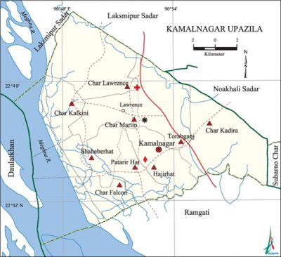
Kamalnagar Upazila
Kamalnagar Upazila (lakshmipur district) area 314.86 sq km, located in between 90°45' and 90°59' north latitudes and in between 22°39' and 22°51' east longitudes. It is bounded by lakshmipur sadar upazila on the north, ramgati upazila on the south, noakhali sadar and subarna char upazila on the east and daulatkhan upazila on the west.
Population Total 222915, male 111245, female 111670; Muslim 219054, Hindu 3853 , Christian 4, Buddhist 1 and others 3.
Water bodies Main river: meghna.
Administration Kamalnagar upazila was formed on 20 June 2006.
| Upazila | ||||||||
| Municipality | Union | Mouza | Village | Population | Density (per sq km) | Literacy rate (%) | ||
| Urban | Rural | Urban | Rural | |||||
| - | 9 | 24 | 33 | 12747 | 210168 | 708 | 41.0 | 30.1 |
| Upazila Town | ||||||||
|
Area (sq km) |
Mouza |
Population |
Density (per sq km) |
Literacy rate (%) | ||||
| 7.77 | 1 | 12747 | 1641 | 41.0 | ||||
| Union | ||||
| Name of union and GO code | Area (acre) | Population | Literacy rate (%) | |
| Male | Female | |||
| Char Kadira 63 | 9880 | 11623 | 12112 | 21.2 |
| Char Kalkini 71 | 9880 | 15760 | 14597 | 24.2 |
| Char Falcon 47 | 6175 | 9127 | 9274 | 40.0 |
| Char Lawrence 79 | 8398 | 11229 | 11652 | 33.3 |
| Char Martin 81 | 8892 | 12386 | 12771 | 24.1 |
| Torabganj 91 | 9880 | 9948 | 11094 | 34.9 |
| Patarir Hat 87 | 5681 | 10663 | 10086 | 26.7 |
| Shaheberhat 95 | 12350 | 16239 | 15070 | 27.8 |
| Hajirhat 83 | 6669 | 14270 | 15014 | 45.1 |
Source Bangladesh Population Census 2001, Bangladesh Bureau of Statistics.
War of Liberation Freedom fighters of the upazila had encounters with the Pak army at Ramgati Police Station, Zamidarhat, Hazirhat and some other places of the upazila. 23 razakars were killed in the encounter and freedom fighters had captured the arms and ammunitions of the collaborators. There is a mass grave at Munshirhat.
For details: see কমলগঞ্জ উপজেলা, বাংলাদেশ মুক্তিযুদ্ধ জ্ঞানকোষ (Encyclopedia of Bangladesh War of Liberation), বাংলাদেশ এশিয়াটিক সোসাইটি, ঢাকা ২০২০, খণ্ড ২।

Noted religious institutions Mohammad Hawlader Mosque (1915), Torabganj Jami Mosque, Hajirhat Jami Mosque (1960), Karuna Nagar Satya Gopal Mandir.
Literacy rate and educational institutions Average literacy 30.7%; male 32.2%, female 29.3%. Noted educational institutions: Char Jangalia SC High School (1932), Char Lawrence High School (1968), Towaha Memorial Girls' High School' (1992), Hajirhat Millat Academy (1958), Hajirhat Hamidia Fazil Madrasa (1950).
Cultural organisation Library 1.
Main crops Paddy, ground nut, mustered seed.
Communication facilities Pucca road 62 km, semi-pucca road 12 km and mud road 24 km; waterway 24.71 km.
Noted cottage industries Pottery, iron works, bamboo works.
Hats, bazars and fairs Hats and bazars are 5, most noted of which are Ludhua Bazar, Hajirhat, Char Lawrence Bazar and Torabganj Hat.
Main export Hilsa fish.
Access to electricity All the unions of the upazila are under rural electrification net-work. However 16.8% of the dwelling households have access to electricity.
Sources of drinking water Tube-well 85.4%, tap 0.4% and others 14.2%.
Sanitation 58.1% of dwelling households of the upazila use sanitary latrines and 34.5% of dwelling households use non-sanitary latrines; 7.4% of households do not have latrine facilities.
Health centres Upazila health complex 1, union health centre 5.
Natural disasters About 70 persons were victims of small pox and cholera disease in 1957. Besides, a few thousand people were victims of flood occurred in 1970.
NGO activities Prayas, Upakul (coastal area) Samaj Unnayan Sangstha. [Nazimuddin Mahmud]
References Bangladesh Population Census 2001 and 2011, Bangladesh Bureau of Statistics; Field survey report of Kamalnagar Upazila 2007.
