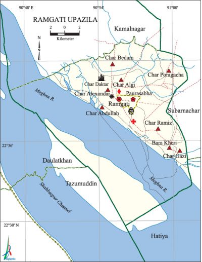
Ramgati Upazila
Ramgati Upazila (lakshmipur district) area 279.88 sq km, located in between 22°52' and 22°90' north latitudes and in between 90°47' and 91°01' east longitudes. It is bounded by kamalnagar on the north, hatiya upazila and meghna river on the south, subarnachar upazila on the east, tazumuddin and daulatkhan upazilas and Meghna river on the west.
Population Total 261002; male 128449, female 132553; Muslim 249958, Hindu 10986 , Christian 53, Buddhist 4 and others 1.
Water bodies Main rivers: Meghna.
Administration Ramgati Thana was formed in 1862 and it was turned into an upazila in 1983.
| Upazila | ||||||||
| Municipality | Union | Mouza | Village | Population | Density (per sq km) | Literacy rate (%) | ||
| Urban | Rural | Urban | Rural | |||||
| 1 | 8 | 24 | 48 | 59837 | 201165 | 933 | 38.7 (2001) | 36.6 |
| Municipality | ||||||||
| Area (sq km) |
Ward | Mahalla | Population | Density (per sq km) |
Literacy rate (%) | |||
| - | 9 | 11 | 24016 | - | 51.9 | |||
| Upazila Town | ||||||||
|
Area (sq km) |
Mouza |
Population |
Density (per sq km) |
Literacy rate (%) | ||||
| 71.64 (2001) | 2 | 35821 | 864 (2001) | 45.1 | ||||
| Union | ||||
| Name of union and GO code | Area (acre) | Population | Literacy rate (%) | |
| Male | Female | |||
| Char Abdullah 15 | 8645 | 9715 | 9076 | 20.5 |
| Char Algi 31 | 6916 | 13177 | 14892 | 51.9 |
| Char Alexandar 23 | 10374 | 20532 | 20446 | 41.3 |
| Char Poragacha | 10127 | 12612 | 14062 | 32.9 |
| Char Gazi 55 | 12150 | 21660 | 21230 | 27.9 |
| Char Bedam 39 | 7410 | 10110 | 11156 | 37.3 |
| Char Ramiz 87 | 7163 | 20871 | 21868 | 43.6 |
| Bara Kheri 13 | 3458 | 7817 | 7762 | 44.9 |
Source Bangladesh Population Census 2001 and 2011, Bangladesh Bureau of Statistics.

Archaeological heritage Bedar Boksh Mosque, Rani Bhabani Kamada Math.
War of Liberation During the war of liberation in 1971 a battle was fought between the freedom fighters and the Pak army at the turn of the Zamindar Hat in which 17 Pakistani soldiers and a number of razakars were killed.
For details: see রামগতি উপজেলা, বাংলাদেশ মুক্তিযুদ্ধ জ্ঞানকোষ (Encyclopedia of Bangladesh War of Liberation), বাংলাদেশ এশিয়াটিক সোসাইটি, ঢাকা ২০২০, খণ্ড ৯।
Religious institutions Mosque 105, temple 10, math 1. Noted religious institutions: Ramgati Central Jami Mosque, Char Poragachha Mosque, Bedarbox Mosque, Ashrama of Bura Karta, Rani Bhabani Kamda Math.
Literacy rate and educational institutions Average literacy 39.3%; male 40.4%, female 38.3%. Educational institutions: college 4, secondary school 27, primary school 145, madrasa 46. Noted educational institutions: Alexandar Govt. College (1970), Ramgati Ahamadia College (1983), Abdul Hadi College, Town Alexandar Mohila College, ASM Abdur Rob Govt. College, Ramgati BBK Pilot Ideal High School (1933), Char Sita Torab Ali High School (1947), Ramgati Acchiya Pilot Girls School (1968), Alexandar Pilot Girls School (1972), Balu Char Islamia Senior (Alim) Madrasa (1933), Char Alexandar Alia Madrasa (1938).
Newspapers and periodicals Periodical: Ramgati Darpan, Swadesh Bhumi.
Cultural organisations Library 4, club 12, theater group 3, cinema hall 3, women's organisation 23.
Main sources of income Agriculture 66.56%, non-agricultural labourer 4.00%, industry 0.53%,' commerce 11.25%, transport and communication 1.53%, service 4.58%, construction 0.81%, religious service 0.31%, rent and remittance 0.31% and others 10.12%.
Ownership of agricultural land Landowner 48.81%, landless 51.19%; agricultural landowner: urban 40.10% and rural 50.41%.'
Main crops Paddy, wheat, chilli, onion, ground nut, soybean.
Extinct or nearly extinct crops Kaun, barley, jute.
Main fruits Mango, jackfruit, guava, coconut, betel nut.
Fisheries, dairies and poultries Fishery 58, Dairy 9, poultry 40.
Communication facilities Pucca road 100 km, semi-pucca road 52 km, mud road 301 km; waterway 24 km.
Extinct or nearly extinct traditional transport Palanquin and bullock cart.
Noted manufactories Rice mill, flour mill, saw mill, ice-crime factory, bidi factory.
Cottage industries Goldsmith, blacksmith, weaving, bamboo work, wood work.
Hats, bazars and fairs Hats and bazars are 50, fairs 2, most noted of which are Alexandar Hat, Ramgati Hat, Karunanagar Hat, Zamindar Hat, Bibir Hat, Karaitala Hat, Sennir Hat and Bura Kartar Mela at Alexadar.
Main exports Hilsa fish, shrimp, paddy, ground nut, soybean, chilli.
Access to electricity All the unions of the upazila are under rural electrification net-work. However 17.5% of the dwelling households have access to electricity.
Sources of drinking water Tube-well 85.3%, tap 0.3% and others 14.4%.
Sanitation 55.7% of dwelling households of the upazila use sanitary latrines and 36.1% of dwelling households use non-sanitary latrines; 8.2% of households do not have latrine facilities.
Health centres Upazila health complex 1, satellite clinic 2, family planning centre 9, clinic 2.
Natural disaster More than one lakh people' and several lakhs livestock were victims of the devastating tornado and tidal bore of 11 November 1970; it also caused heavy damages to property of the upazila.
NGO activities Operationally important NGOs are brac, proshika, asa, CODEC, Social Association for Rural Advancedment. [Md Zahir Uddin Babar]
References Bangladesh Population Census 2001 and 2011, Bangladesh Bureau of Statistics; Cultural survey report of Ramgati Upazila 2007.
