Kotwali Model Thana (Barisal Metropolitan)
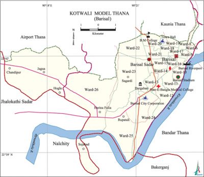
Kotwali Model Thana (Barisal Metropolitan) area 40.33 sq km, located in between 22°38' and 20°43' north latitudes and in between 90°16' and 90°22' east longitudes. It is bounded by kaunia and airport thanas on the north, nalchity and bakerganj upazilas on the south, bandar thana on the east and jhalokati sadar upazila on the west.
Population 165050; male 88821, female 76229; Muslim, 150262, Hindu 12618, Buddhist 2026, Christian 74, and others 70.
Water bodies Main river:' kirtanhkHola.
Administration Kotwali thana was formed in 2007 comprising 20 wards and Jagua Union of Barisal Sadar upazila.
| Thana | ||||||
| Ward | Mohalla | Population | Density (per sq km) | Literacy rate (%) | ||
| Urban | Rural | Urban | Rural | |||
| 21 | 45 | 127315 | 37735 | 4093 | 75.12 | 68.04 |
| Ward | ||||
| Name number of Ward | Area (sq km) | Population | Literacy rate (%) | |
| Male | Female | |||
|
Ward No. 6 |
0.37 |
1561 |
1419 |
80.76 |
|
Ward No. 8 |
0.56 |
2504 |
2365 |
71.31 |
|
Ward No. 9 |
0.87 |
6950 |
6397 |
45.88 |
|
Ward No. 10 |
0.79 |
5775 |
4729 |
56.66 |
|
Ward No. 11 |
0.51 |
3525 |
1651 |
79.53 |
|
Ward No. 12 |
0.48 |
2313 |
1526 |
88.93 |
|
Ward No. 13 |
0.56 |
2056 |
693 |
79.68 |
|
Ward No. 14 |
0.49 |
2784 |
1630 |
72.91 |
|
Ward No. 15 |
0.47 |
3454 |
2607 |
58.23 |
|
Ward No. 16 |
1.00 |
5540 |
4818 |
71.15 |
|
Ward No. 17 |
0.91 |
3867 |
3939 |
80.46 |
|
Ward No. 18 |
0.59 |
2834 |
2504 |
81.04 |
|
Ward No. 19 |
0.61 |
2223 |
2124 |
76.02 |
|
Ward No. 20 |
0.91 |
4062 |
3726 |
72.21 |
|
Ward No. 21 |
0.77 |
3458 |
3235 |
78.54 |
|
Ward No. 22 |
0.79 |
2534 |
2183 |
87.21 |
|
Ward No. 23 |
0.74 |
4448 |
4127 |
78.98 |
|
Ward No. 24 |
0.70 |
2678 |
2573 |
78.38 |
|
Ward No. 25 |
0.99 |
3453 |
3116 |
79.91 |
|
Ward No. 26 |
1.00 |
3109 |
2825 |
85.33 |
|
Jagua Union 60 |
26.22 |
19693 |
18042 |
68.04 |
Source Bangladesh Population Census- 2001, Bangladesh Bureau of Statistics.
Religious institutions Jami Kasai Mosque, Kalu Shah Road Mosque, Jami Ebadullah Mosque, Barisal Muslim Graveyard Mosque, Madrasa and Orphanage, Mazar of Hazrat Lechu Shah, Ramkrishna Mission, Shankar Math, Kalibari, Oxford Mission Church and St Piter's Catholic Church are notable.

Literacy rate and educational institutions Average literacy 74.82%; male 77.17%, female 71.91%. Noted educational institutions: BM College (1884), Barisal Polytechnic Institute (1962), Sher-e- Bangla Medical College (1969), Amritalal Dey College (1992), Barisal Government College, Government Syed Hatem Ali College, Barisal Government Women's College, Barisal Model School and College, Barisal Zila School, Brajamohan School, Oxford Mission High School, Udayan High School and Char Monai Madrasa.
Cultural organisations Public library 3, cinema hall 1, stadium 1.
Important establishments and tourist spots Barisal Collectorate Bhaban, District Judge Court, Headquarters of Metropolitan Police, Office of the Road and Waterways Authority, Police Line, Fisheries Bhaban, Fire Service, Bangladesh Bank, City Corporation Office, Rice Research Centre, Interdistrict Bus Terminal, Bangladesh Radio (Barisal Station), Barisal Stadium, Bibir Pond, Bell's Park, etc.
Main sources of income Industry 1.98%, agriculture 5.18%, non-agricultural labourer 5.47%, commerce 28.42%, transport 7.12%, construction 4.34%, service 30.18%, religious service 0.39%, rent and remittance 2.29% and others 14.63%.
Ownership of agricultural land Landowner 42.69%, landless 57.31%.
Main crops Rice, wheat, betel leaf, sugarcane, vegetables.
Extinct or nearly extinct crops Sesame, linseed, mustard seed, sweet potato, leguminous seeds of pulse, jute.
Main fruits Mango, jackfruit, litchi, papaya, black berry, coconut, betel nut.
Fisheries, dairies and poultries There are quite a number of fisheries, dairies and poultries in the thana.'
Extinct of nearly extinct traditional transport Palanquin, bullock cart and horse carriage.
Noted manufactories Jute mill 1, Cotton mill 1.
Cottage industries 'Goldsmith, blacksmith, wood work, welding.
Hats and bazars Venus Market, Bangla Bazar, Puran Bazar, Chaumatha Bazar, Fish offloading Centre and wholesale Market, etc.
Hotels and restaurants Rose Garden, Yan Thai, Kirtankhola Garden.
Access to electricity All the wards and union of the thana are under electrification net-work. However 80.47% of the dwellings have access to electricity.'
Sources of drinking water Tube-well 71.02%, pond 1.91%, tap 25.46.50% and others 1.61%.
Sanitation 82.45% of the dwelling households use sanitary latrines and 14.4% use non-sanitary latrines; 3.15% of' the dwelling households do not have sanitation facilities.
NGO activities operationally important NGO's are brac, proshika, asa CARITAS.
Health centres Hospital 2, family planning centre 7, private health centre 11. Noted health centres are Sher-e-Bangla Medical College, Captain Nazibuddin Clinic. [Akhtaruddin Chowdhury]
References Bangladesh Population Census 2001, Bangladesh Bureau of Statistics.
