Natural Hazard
Natural Hazard any natural event which has an adverse socio-economic impact on the human being. Alternatively, an extreme natural event, such as a cyclone, an earthquake or a flood, that is not caused by human beings. These are naturally occurring phenomena that only become hazardous due to the intervention of human infrastructure. The vulnerability of human infrastructure to destruction (risk) by a disaster is also an important factor in understanding natural hazards. The distribution and impact of natural hazards is unequal with greatest loss of life and property in the developing part of the world. This is not because of greater hazard frequency but simply because of greater vulnerability.
Therefore, the people in the developing countries are at high risk than those of developed countries. Combining the risk factor the natural hazard can be defined as the probability of a change in the natural environment of a given magnitude occurring within specified time period in a given area while the associated risk is the consequent damage or loss of life, property and services. The frequency of major hazard appears to have increased since 1960 and the number of people killed each year has decreased at a rate of about 6% and the loss or property has also decreased steadily. This has taken place owing to increased awareness and better hazard management. The increase in the frequency of hazard can be assigned to such factors as better global news coverage, increasing population, increasing urbanisation and increasing natural degradation. Natural hazards are now being considered as of global importance and global efforts are being made to mitigate them.
Natural hazards can be identified into three broad groups such as atmospheric hazards caused by atmospheric processes (storm, cyclone, nor’wester, tornado, hurricane, drought etc), exogenic hazards caused by the earth surface processes (flood, riverbank erosion, coastal erosion, landslide,soil erosion,and groundwater contamination), and endogenic hazards caused by internal earth processes (earthquake and volcanic eruption). On many occasions there are overlaps between these different events. Natural hazards can be profiled against seven basic criteria viz. event magnitude, frequency of occurring, duration, areal extent, speed of onset, spatial dispersion and temporal spacing.
In Bangladesh the risks of atmospheric and exogenic hazards are high whereas risk from endogenic hazards are relatively low. Cyclone, flood, riverbank erosion, coastal erosion, landslide, drought and groundwater contamination are major natural hazards. Among the endogenic hazards, Bangladesh have risks from earthquake only, not from volcanic activity. The greatest natural hazard currently being confronted by Bangladesh is the contamination of groundwater by arsenic.
Storm A violent disturbance of the atmosphere, taking the form of high winds, often heavy rainfall, thundering and lighting, rough conditions with high foaming waves at sea. Tropical cyclones, tornadoes, thunderstorms, tropical depressions are the common types of storms that occur in Bangladesh.
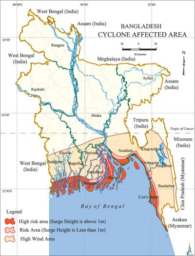
Cyclone Devastating cyclones hit the coastal areas of Bangladesh almost every year usually accompanied by high-speed winds, sometimes reaching 250 km/hr or more and 3-10m high waves, causing extensive damage to life, property and livestock. Cyclones in the bay of bengal occur in two seasons, April-May and October-November - ie before and after the monsoon. Cyclones enter the Bay as the remnants that originate in the South China Sea. They gain moisture and latent heat from the Bay of Bengal, and consequently rejuvenate into full-blown phenomenon. Following a curvilinear path, they reach the coast of Myanmar, Bangladesh or East Coast of India. Because of the funnel shaped coast, Bangladesh repeatedly becomes the landing ground of cyclones formed in the Bay of Bengal. The Bay cyclones also move towards the eastern coast of India, towards Myanmar and occasionally into Sri Lanka. But they cause the maximum damage when they come into Bangladesh and West Bengal of India. This is because of the low flat terrain, high density of population and poorly built houses. Most of the damage occur in the coastal regions of Khulna, Patuakhali, Barisal, Noakhali and Chittagong and the offshore islands of Bhola, Hatiya, Sandwip, Manpura, Kutubdia, Maheshkhali, Nijhum Dwip, Urir Char and other newly formed islands.
Tornado It occasionally occurs in Bangladesh during the pre-monsoon hot season, especially in the month of April when the temperature is the highest. The diameter of a tornado varies from a few metres to about two kilometres. The rotating winds attain velocities of 300 to 480 km/hr and the updraft at the centre may reach 320 km/hr. A tornado is usually accompanied by thunder, lighting, terrifying roaring and heavy rain. Tornado is a very short-lived disturbance which may last 10-20 minutes and the length of their travel path may vary from 10 to 15 km. Although small in size, wherever they hit, they make a complete devastation.
They are more common in the central part of Bangladesh than in the other areas. Most of the severe tornadoes are recorded in the district of Faridpur, Rajbari, Gopalganj, Madaripur, Pabna, Gazipur, Tangail and Dhaka areas.
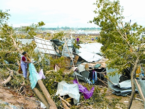
Nor'wester Generally blows over Bangladesh in April-May from the north-westerly direction, locally known as Kal-Baishakhi. The difference between an ordinary shower and this storm is that it is always associated with thunder and lightning. Hail is common with a nor'wester. From mid-March to April the temperature in Bangladesh rises sharply. In the middle of April the whole country, especially the northwestern part, records a sharp rise of day temperature. Nor'westers are more frequent in late afternoon because of the influence of surface heating in producing convection currents in the atmosphere. In the western region of Bangladesh, nor'wester comes in the late afternoon and before evening but in the eastern side it comes generally after evening coinciding its movements from north-westerly to easterly and southeasterly direction. The average wind speed of nor'wester is 40-60 km per hour, but in exceptional circumstances the wind speed may exceed 100 km. The duration of nor'wester is shorter but sometimes may last over an hour. [Rafique Ahmed and Masud Hasan Chowdhury]
Storm surge and tidal bore The storm surges that accompany the cyclones of the Bay of Bengal cause more destruction in the coastal areas and offshore islands of Bangladesh than the very strong winds that are associated with the cyclones. Such destruction includes the widespread demolition of houses, uprooting of trees, damage of crops, roads, buildings and structures, and death to human and loss of livestock. Tidal bore is also known as ban in Bangla. In Bangladesh, tidal bore is observed in the Meghna estuary and other southern coastal areas in the months of April-May and also between September-December. It is much more devastating in Chittagong, Cox's Bazar, Barisal, Noakhali, Patuakhali, Barguna and Khulna. In the Meghna estuary, the 1970 Cyclone (Nov 12-13) with cyclonic surge of 3.05m to 10.6m high with wind speed of 222 km/h occurred during high tide causing most appalling natural disaster claiming 0.3 million human lives. On the 29 April 1991 a devastating cyclone hit Chittagong, Cox's Bazar, Barisal, Noakhali, Patuakhali, Barguna and Khulna along with tidal bore of 5-8m high with wind speed of 240 km/h which killed 150,000 human beings, 70,000 cattlehead, and the total loss was about Tk 60 billion. [HS Mozaddad Faruque]
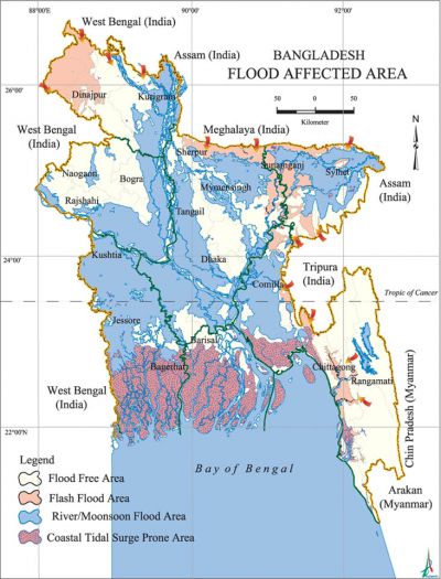
Flood Inundation of land by the rise and overflow of a body of water. Floods occur most commonly when water from heavy rainfall, from melting ice and snow, or from a combination of these exceeds the carrying capacity of the river system, lake or ocean into which it runs. Every year near about one-fifth of Bangladesh undergoes flood during the monsoon season. The geographic position, structural set-up, physiography and geomorphology are jointly responsible for flooding in the country. A flood season in Bangladesh may start as early as May and can continue until November. Five floods during the last fifty years are extensive and devastating and these are the floods of 1955, 1974, 1987, 1988, and 1998. The harrowing condition caused by these floods (particularly 1987 and 1988) aroused the conscience of the international community, which lead to the formation of flood action plan (FAP).
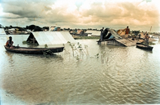
Floods of Bangladesh can be divided into three categories: (i) monsoon flood - seasonal, increases slowly and decreases slowly, inundate vast areas and causes huge loss to the life and property; (ii) flash flood-from sudden torrential flows, following a brief intense rainstorm or the bursting of a natural or man made dam or levee; and (iii) tidal flood - short duration, height is generally 3-6m, prevents inland flood drainage. The possible contributing factors for causing floods in Bangladesh are: (a) general low topography of the country with major rivers draining through Bangladesh including congested river network system, (b) heavy rainfall in the up-country or in-country, (c) snow melt in the Himalayas and glacial displacement (natural), (d) river siltation, lateral river contraction or landslides, (e) synchronisation of major river peaks and influences of one river on the other, (f) human interference, (g) tidal and wind effects on slowing down the river outflow (back water effect), (h) effect of sea level change, (i) possible rise in sea bed and land subsidence, (j) tectonic anomalies (earthquake, change in river flow/ morphology etc), (k) possible green house effect, and (l) experiments on melting of glaciers in the Himalayas.
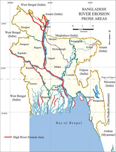
Riverbank erosion Every year millions of people of the country are affected by riverbank erosion that destroys standing crops, farmland and homestead land. It is estimated that about 5% of the total floodplain of Bangladesh is directly affected by riverbank erosion. Riverbank erosion is taking place in about 94 upazilas out of 496 upazilas/thanas of the country. Over 25,000 families were rendered homeless in June 1993 by riverbank erosion in 16 districts. During monsoon, extensive overbank spills, bank erosion and bankline shifts have become typical. The unpredictable shifting behavior of the rivers and their encroachments not only affect the rural floodplain population but also the urban growth centres and infrastructures.
The rivers that are highly susceptible to riverbank erosion are ganges, jamuna, padma and Lower Meghna. Along the right and left banks of the Ganges, erosion rates are 56m and 20m per year respectively. The rate of widening of the Jamuna within the period 1973 to 2000 is 128m/year. In this period, the average width of Jamuna increased from 9.7 to 11.2 km. The maximum bank erosion during 1984-92 occurred at the left-bank, just upstream of Aricha. The widening of Jamuna in a 28-year period resulted in a loss of floodplain of 70,000 ha over the total 220-km length of the river in Bangladesh. Banklines of Padma are very unstable and the widening rate is 159m/year. The Lower Meghna river eroded both its banks, causing formation of medial bars.
Downstream of Chandpur, the westward bank erosion during 1984-1993 was severe with the rate of erosion at times getting as high as 824m/year, higher than the widening rate of the Jamuna during the same period (184 m/year).
This erosion-accretion phenomenon is a characteristic feature of the courses of the rivers in Bangladesh and gives rise to a lot of local politics.
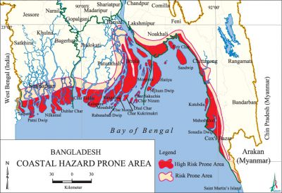
Coastal erosion The deltaic coastline of Bangladesh can be recognised as consisting of two basic physiographic units: the inactive or abandoned Ganges tidal plain and the active Meghna deltaic plain. While the Ganges tidal plain is relatively old, the Meghna deltaic plain is geologically very young. The Meghna deltaic plain extends from the Chittagong coast in the east to Tentulia Channel in the west. The erosion-accretion processes take place much more within this part. Broad map comparisons indicate that the delta of the Ganges-Brahmaputra rivers has not grown significantly toward the sea over last two centuries. Changes can be noticed in Sandwip and adjacent islands, in Hatiya island, in Bhola Island, and in the coastline of the Noakhali mainland. Sandwip island reduced in size in about 200 years. Sandwip channel was nearly isolated from the main distributary network of the rivers in 1764-1793. The Hatiya island elongated and migrated considerably southward during this period. Bhola island is also elongated north-south. The islands, in general, prograded by about 50 km southward.
Landslide Common in the hilly areas of southeastern Bangladesh, especially in Bandarban, Rangamati, Khagrachhari and Cox's Bazar. Every year especially in the rainy season landslides take place in both natural and man-induced slopes. The major roads connecting Bandarban town with the rest of the country is affected by landslides almost every year isolating the town and contiguous areas. Not only are roads but also a considerable number of infrastructures are damaged and valuable lives lost. Landslides due to the construction of buildings and other infrastructures have been mostly restricted to the urban and semi-urban centres of hill districts. The effect of jhum cultivation and other forms of cultivation on steep slopes also play a significant role in the occurrence of landslide. Hill cutting is a major cause of landslide. Common engineering techniques for landslide prevention include provision for surface and subsurface drainage, removal of unstable slope materials, construction of retaining walls, or some combination of these. Many of them are currently used in Bangladesh. A successful integrated bioengineering and drainage control approach (Geo-Jute Textile method) for landslide protection and mitigation was carried out at Bandarban. [Sifatul Quader Chowdhury]
Arsenic In Bangladesh and West Bengal, alluvial Ganges aquifers used for public water supply are polluted with naturally occurring arsenic, which adversely affects the health of millions of people. In Bangladesh arsenic occurrences have been found to be restricted mostly in the southern (Lakshmipur, Noakhali, Chandpur), southwestern (Kushtia, Jessore, Faridpur) and western parts (Nawabganj) of the country, which comprises the Ganges Deltaic Plain. Arsenic concentrations are mainly confined to the upper 100m of the aquifer. Natural processes of groundwater flushing will eventually wash the arsenic away but this will take thousands or tens of thousands of years. Arsenic contamination in West Bengal occurs in similar geological and hydrogeological conditions. Arsenic contamination in groundwater is not a new health hazard faced by mankind and it can be managed successfully.
Short-term measures such as identification of the contaminated wells, use of treated surface water, rainwater and home level arsenic removal plants can be adopted. Long term measures such as replacement of wells in uncontaminated aquifers, installation of community arsenic removal plants and piped water supply from treated surface water can be considered. Effect of irrigation with arsenic contaminated water should also be considered in the long-term study. Groundwater abstraction should be kept in the minimum and conjunctive use of surface water and groundwater should be adopted as the policy of future water development. [M Qumrul Hassan]
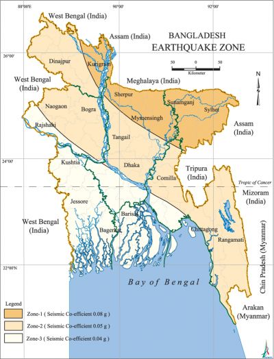
Earthquake In the north and northeast of Bangladesh, there are areas of high seismic activity and some of the major earthquakes originating in these areas have affected the adjacent regions of the country. The whole of Bangladesh is divided into three seismic zones. The northern part of the country that includes the greater districts of Rangpur, Mymensingh, and Sylhet are in the Zone-I where earthquake shock of maximum intensity of IX of the Modified Mercalli Scale is possible. The Zone-II includes the greater districts of Dinajpur, Bogra, Dhaka and Chittagong and the shocks of intensity of VIII are possible. The southern part of the country, the least active region, where the maximum intensity is not likely to exceed VII, is in the Zone-III. The experts suggest not to construct normal buildings with more than 60m height.
The incidences of major earthquakes in and around Bangladesh showing the name, occurring date, epicentre, and magnitude in Richter Scale accordingly are: the Cachar Earthquake (1 October 1869, Jaintia Hills, 7.5); the Bengal Earthquake (14 July 1885, Bogra Fault, 7.0); the Great Indian Earthquake (12 December 1897, Shillong Plateau, 8.7); Sreemangal Earthquake (8 July 1918, Balisera Valley of Sreemangal, 7.3); the Dhubri Earthquake (3 July 1930, Dhubri Town in Assam, 7.1); the Bihar-Nepal Earthquake (15 January 1934, Darbhanga, 8.3); the Assam Earthquake (15 August 1950, Aurunachal in Assam, 8.5). Very recently, there had been earthquakes in Bangladesh and adjacent areas: The Sylhet Earthquake (5 August 1997, epicentre not known, 6.00); the Chittagong Earthquake (21 November 1997, Indo-Bangladesh Border, 6.00); and the Maheshkhali Island Earthquake (22 July 1999, West of Maheshkhali Island, 5.2). There is only one earthquake recording station in Bangladesh, which is in Chittagong city and is under the Meteorological Department of Bangladesh. [Md Khurshid Alam]
Bibliography AM Chowdhury, 'Rose Petals for Tropical Cyclones', Nuclear Science and Applications (118), 1978; AM Chowdhury et al, 'Sterering Wind Effects on Cyclone Tracks in the Bay of Bengal', The Dhaka University Journal of Science 43 (1), January 1995; BBS, 1998 Statistical Yearbook of Bangladesh (19th edition), Bangladesh Bureau of Statistics, Government of the People's Republic of Bangladesh, 1999; K Nizamuddin ed, Disaster in Bangladesh: Selected Readings, Disaster Research Training and Management Centre, University of Dhaka, 2001.
