World Heritage Sites
World Heritage Sites are declared by the UNESCO considering the leading natural and cultural features of the objects prevailing worldwide including Bangladesh. About 890 famous sites were declared as World Heritage Sites for having such unique features till 2009. Among those, 689 sites have rich cultural heritage, 176 are naturally unique and 25 sites bear both the features. The World Heritage Committee, the approving body of UNESCO has divided the globe into five geographical zones. These are (1) Africa and Arab Zone (including the Middle East), (2) Asia and the Pacific Zone (including Australia and Oceania) (3) Europe and North America (4) Latin America and (5) Caribbean. New world heritage sites are declared every year after the approval of the World Heritage Committee. If any enlisted site is not maintained properly, the Committee omits its name from the list. The World Heritage Committee is constituted for a period of four years comprising representatives from 21 countries across the globe.
The Committee also supervises the management function of each of the world heritage site. All declared world heritage sites are given financial support from the World Heritage Fund for proper protection and maintenance. The UNESCO adopted this decision of extending financial support in its special meeting on 16 December 1972. So far, 186 countries of the world including Bangladesh ratified the 'Convention Concerning the Protection of World Cultural and Natural Heritage'.
Three spots of Bangladesh have been declared world heritage sites till 2009. These are: Paharpur Buddhist Monastery of Noagaon, Bagerhat Mosque City and the Sundarbans. The first two sites are parts of world cultural heritage and the rest belongs to world's natural heritage, as the Sandarbans is the largest mangrove forest of the world.

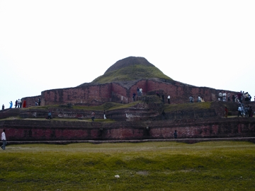
Paharpur Buddhist Monastery, also known as the somapUra mahavihara, was declared a world heritage site in 1985. buchanan Hamilton spotted this archaeological site in 1807-12. alexander cunningham, a famous archaeologist visited this site in 1879 and identified it as a Hindu temple. archaeological survey of india, varendra research society and University of Calcutta jointly started excavation in this site in 1923. Excavation work of this archaeological site was carried out in several phases throughout Pakistan era, and in the post liberation era in sovereign Bangladesh. Remains of a large Buddhist monastery of 274.15 metre x 273.70 metre area was discovered here.
The World Heritage Committee includes a site in its heritage list considering several criteria. It declared Paharpur a new world heritage site considering the fact that it was a unique architectural monument of pre-Islamic era located to the south of Himalaya. The temple in the centre of the single largest architectural complex of the ancient periodwas a rare example of artwork on stone reliefs and terracotta plaques of Pala era depicting an extraordinary aesthetical outlook. It has been presumed that the architectural design of the Paharpur monastery had influenced the architects of Ananda Temple of Pagan, Myanmar and Lor Jangrang and Chandi Sheua temples of Java.
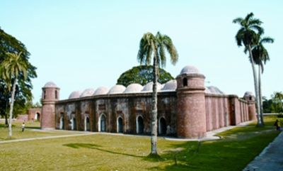
Bagerhat-Khalifatabad the mosque city of mediaeval age famous for its various archeological edifices is situated in Bagerhat district, north of Sundarbans. shatgumbad mosque. bibi begni Mosque, chuna khola Mosque, Zindapeer Mosque, nine-domed Mosque, Rejakhoda Mosque, Ranabijoypur Mosque, Shabekdanga Namajghar, singra mosque, Khan Jalan's Residence and the Tomb complex are remarkable heritage sites of high archaeological merit.

Shatgumbad Mosque is an enormous and magnificent architectural establishment of khalifatabad town. The Shatgumbad Mosque was not only a place of worship, it was used as the seat of administration as well as the centre for education and a meeting place during the rule of Khan Jahan, a great saint and ruler of Khalifatabad. The mosque is considered as the most massive and magnificent architectural monument built by Khan Jahan.
Bibi Begni Mosque another site enlisted in the world heritage list, is located beside the Shatgumbad Mosque over an area of only 10 square metre. It has four corner towers, three arched doorways on the east wall and one archway each on the north and south walls.
Chunakhola Mosque situated 500 metre east of bibi begum mosque over an area of 12.19 square metre is a single-domed one having four corner towers. Its number and location of arched doorways and archways are similar to the Bibi Begni Mosque.
Nine-Domed Mosque is a rectangular shaped mosque situated on an area of 15.24 square metre on the west bank of nearby Thakur Dighi, a huge water body, also has four corner towers and one archway on each of the east, north and south walls. The interior of the mosque is divided by two rows of stone-pillars into three longitudinal aisles and nine bays. One dome on each of the bays gave the mosque a unique identity. The Nine-domed Mosque is a rare example in the mosque architecture of Bengal.
Zinda Pir's Mosque The single-domed, although included in the world Heritage site list, the government of Bangladesh has not yet declared it as a protected monument. The department of archaeology renovated the largely damaged mosque, which had similar features of corner towers and archways like Chunakhola Mosque.
The Rejakhoda Mosque appeared to be a six-domed mosque which is situated 200 metre west of the Zinda pir's Mosque. A small part of the remains still exists there. Rana Bijoypur Mosque' The single-domed mosque was built on an area of 12.17 square metre. Its dome is the largest among all the nearby mosques. Its corner towers are similar to other mosques and rich in band decoration.
Shabekdanga a village located 5 k.m east of Shatgumbad Mosque, has got an ancient prayer house called Shabekdanga Namajghar. Perhaps it is the earliest example of chou-chala architecture that exists in Bengal.
Singra Mosque the single domed mosque was constructed about 150-metre southeast of the Shatgumbad Mosque on an area of 12.09 square metre.
Khan Jahan's Tomb is a single-domed square monument. Its architectural design has similarity with the eklakhi mausoleum at Hazrat Pandua. The residence complex of khan jahan is located at a place, 300 metre east of Shatgumbad Mosque. Primary phase of its excavation work has not yet been completed. During the reign of Sultan nasiruddin mahmud shah (1436-1459) of Iliyas Shahi dynasty Commander Ulugh Khan Jahan (death 1459 AD) built the architecturally rich Bagerhat town on the Bhairab river along the Sundarbans about six hundred years back. Later during the reign of nasiruddin nusrat shah (1519-1532), the city was known as a mint town. In 1535 AD, Sultan ghiyasuddin mahmud shah renamed the town as Khalifatabad-Badarpur. The town was also traced in the map drawn by the Portuguese in the sixteenth century. The name of the town was Haweli Khalifatabad up to the eighteenth century. Detail information about Khan Jahan is unavailable, but the landmark buildings and monuments bear testimony of his creation of distinctive architecture. The architecture of Bagerhat represents a Muslim urban site of mediaeval age, which still exits being an administrative centre of the government. Considering all these merits, the world heritage Committee enlisted this town in the World Heritage list in 1985.
Documents were prepared in 1973 to produce before the World Heritage Committee for enlisting Bagerhat Mosque town and Paharpur Monastery. Following the move, UNESCO in its 21st session in 1980 took a resolution in favour and ultimately these two historical sites were declared as world heritage sites in 1985. Later 13,669 hectors of land around Paharpur Monastery was acquired to protect the remains and a Museum and an office complex were built on 1160 square metre of land. In Bagerhat, 4.07 hectors of land was acquired and 994 square metre office building was constructed there. The first international campaign of the working group for preserving the historical sites of Bagerhat and Paharpur was launched in 1986 and the second campaign was conducted in 1990. Following the move, the International Expert Committee paid several visits to Bangladesh in 1989, 1990, 1991, 1993, 1996, 1999 and 2002 to find out the ways and means for protecting the architectural remains. An international seminar on Preservation of Terracotta plaques was held in 2004.
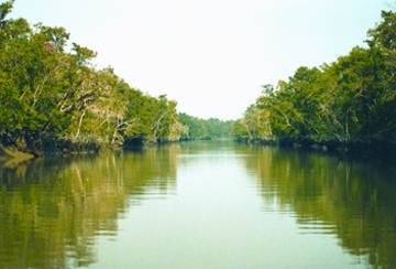
The Sundarbans is the lone world natural heritage site of Bangladesh. This is the largest single block mangrove forest spreading over an area of about 5759 square kilometres in Bangladesh. Because of the partition of India, Bangladesh received 2/3 of the forest and the rest is the on Indian side. The forest in Bangladesh territory lies under four administrative ranges. Those are, Burigoalini, Khulna, Chandpai and Sharonkhola under the districts of Satkhira, Khulna and Bagerhat. It is further divided into nine blocks and 55 compartments for better management. About 32.400 hectares of reserved forest here have been declared as wild life sanctuaries. The Sandurbans consists of about 200 islands, separated by about 400 interconnected tidal rivers, creeks and canals.

The vegetation of the forest is largely of mangrove type and encompasses a variety of plants. The dominating species are: Sundari (Hesitiera fomes) and Gewa (Excoecaria agallocha). Among others Goran (Ceriops decandra). Keora (Sonneratia apetala) and Passur (Xylocarpus mekongensis) are prominent species grown here. Most of the trees have pneamatophores for aerial respiration. In 1903, D. Prain recorded 334 species. Of these 17 are pteridophytes, 87 monocotyledones and the rest are dicotyledones. The species include 35 legumes, 29 grasses, 19 sedges and 18 euphorbias. Of the 50-mangrove plant species recorded so far in the world, the Sundarbans alone contains 35. Within the forest habitats, there are 50 species of mammals, 320 species of inland and migratory birds, about 50 species of reptiles, 8 species of amphibians and about 400 species of fish.
In 1764, the Sundarbans was shown in the map prepared by the surveyor general of the East India Company government of India. In 1860, the Department of Forestry was constituted in the province of Bengal, India, which took over the management of the forest to administer its resources in a proper way. The Forest Act was enacted by the British Indian government in 1865 and under this act, the Sundarbans, a real showpiece of natural history, was declared as a reserve forest in 1875-76. The management plan of the Sundarbans was finalised by 1893-94 and the Department of Forestry was set up with its headquarters in Khulna with a view to fostering the implementation of the Sundarbans management plan. In 1911, the area of the Sundarbans was 16, 902 Square kilometres. It was declared as a Ramsar site in 1992. The World Heritage Committee declared the Sundarbans as a world Natural Heritage site in 1997. [Mokammal H Bhuiyan]
