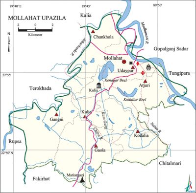
Mollahat Upazila
Mollahat Upazila (bagerhat district) area 187.88 sq km, located in between 22°48' and 22°59' north latitudes and in between 89°40' and 89°57' east longitudes. It is bounded by kalia upazila on the north, fakirhat and chitalmari upazilas on the south, Chitalmari, tungipara and gopalganj sadar upazilas on the east, terokhada and rupsa upazilas on the west.
Population Total 130878; male 65205, female 65673; Muslim 104335, Hindu 26302, Christian 89 and others 152.
Water bodies Main rivers: madhumati, Nalua, chitra, Atharbanki; Kendua Beel, Kodalia Beel and Kata Gang are notable.
Administration Mollahat Thana was formed in 1867 and it was turned into an upazila on 2 July 1983.
| Upazila | ||||||||
| Municipality | Union | Mouza | Village | Population | Density (per sq km) | Literacy rate (%) | ||
| Urban | Rural | Urban | Rural | |||||
| - | 7 | 59 | 103 | 12874 | 118004 | 697 | 55.1 | 49.5 |
| Upazila Town | ||||||||
|
Area (sq km) |
Mouza |
Population |
Density (per sq km) |
Literacy rate (%) | ||||
| 8.79 | 8 | 12874 | 1465 | 55.1 | ||||
| Union | ||||
| Name of union and GO code | Area (acre) | Population | Literacy rate (%) | |
| Male | Female | |||
| Atjuri 09 | 6690 | 10750 | 10836 | 53.3 |
| Udaypur 95 | 6442 | 11519 | 11472 | 52.6 |
| Kulia 85 | 4308 | 8926 | 9147 | 45.9 |
| Kodalia 76 | 7619 | 9725 | 9726 | 47.4 |
| Gaola 47 | 10138 | 7539 | 7430 | 55.7 |
| Gangni 38 | 3833 | 8715 | 8948 | 44.8 |
| Chunkhola 28 | 5417 | 8031 | 8114 | 49.9 |
Source Bangladesh Population Census 2011, Bangladesh Bureau of Statistics.

Archaeological heritage and relics Single domed Mosque (Kulia union).
Historical events There was an artificial scarcity of cotton yarn for production of fishing nets in 1943-44 due to black marketing and other reasons. As a result the fishermen were jobless and they organized a movement.
War of Liberation During the war of liberation in 1971 a battle was fought between the freedom fighters and the Pak army at Chakulia in which about 200 Pakistani soldiers including a Captain were killed. A memorial monument has been built at Chakulia.
For details: see মোল্লাহাট উপজেলা, বাংলাদেশ মুক্তিযুদ্ধ জ্ঞানকোষ (Encyclopedia of Bangladesh War of Liberation), বাংলাদেশ এশিয়াটিক সোসাইটি, ঢাকা ২০২০, খণ্ড ৮।
Religious institutions Mosque 267, temple 72, church 2. Noted religious institutions: Single domed mosque at Uttar Kulia, Udaypur Jami Mosque, Mollahat Court Mosque, Udaypur Arua Kandi Baitul Aman Jami Mosque, Duttapara Kali Mandir, Dakshin Ambari Kali Mandir, Matiyar Gazi Mandir.
Literacy rate and educational institutions Average literacy 50.0%; male 50.7%, female 49.3%. Educational institutions: college 4, secondary school 21, primary school 102, madrasa 10. Noted educational institutions: Khalilur Rahman Degree College (1968), Schiadaha Chunkhola MB Secondary School (1916), Angra Government Primary School (1918), Madartali Model Government Primary School (1928), Udaypur Jamia Halimia Darul Ulum Madrasa (1920).
Newspapers and periodicals Weekly: Mollahat Barta (defunct).
Cultural organisations Club 7, playground 20.
Main sources of income Agriculture 69.17%, non-agricultural labourer 2.58%, industry 0.83%, commerce 10.38%, transport and communication 3.24%, service 6.77%, construction 0.59%, religious service 0.40%, rent and remittance 0.59% and others 5.45%.
Ownership of agricultural land Landowner 64.58%, landless 35.42%; agricultural landowner: urban 45.62% and rural 66.51%.
Main crops Paddy, jute, sugarcane, wheat, sesame, betel leaf, pulse, vegetables.
Extinct or nearly extinct crops Tobacco.
Main fruits Mango, jackfruit, banana, papaya, coconut, betel nut, date.
Fisheries, dairies and poultries Fishery (shrimp cultivation) 10000, poultry 159.
Communication facilities Pucca road 184 km, semi-pucca road 12 km, mud road 311 km.
Extinct or nearly extinct traditional transport Palanquin, horse carriage, bullock cart.
Noted manufactories Rice mill, ice factory, bidi factory, saw mil.
Cottage industries Goldsmith, blacksmith, potteries, embroidery, bamboo work, wood work, cane work, nakshi kantha, nakshi pakha, mat manufacturing.
Hats, bazars and fairs Hats and bazars are 33, fairs 4, most noted of which are Garka Hat, Nagarkandi Hat, Nashuakhali Hat, Kodalia Hat, Chander Hat and Paddodanga' Kali Puja Mela.
Main exports Betel leaf, sugarcane, date molasses, coconut, betel nut, banana, papaya, fish.
Access to electricity All the unions of the upazila are under rural electrification net-work. However 49.9% of the dwelling households have access to electricity.
Sources of drinking water Tube-well 94.5%, tap 2.7% and others 2.8%.
Sanitation 89.1% of dwelling households of the upazila use sanitary latrines and 9.3% of dwelling households use non-sanitary latrines; 1.6% of households do not have latrine facilities.
Health centres Upazila health complex 1, union family planning centre 6, clinic 1.
NGO activities Operationally important NGOs are brac, asa, CARE. [Tapos Kumer Biswas]
References Bangladesh Population Census 2001 and 2011, Bangladesh Bureau of Statistics; Cultural survey report of Mollahat Upazila 2007.
