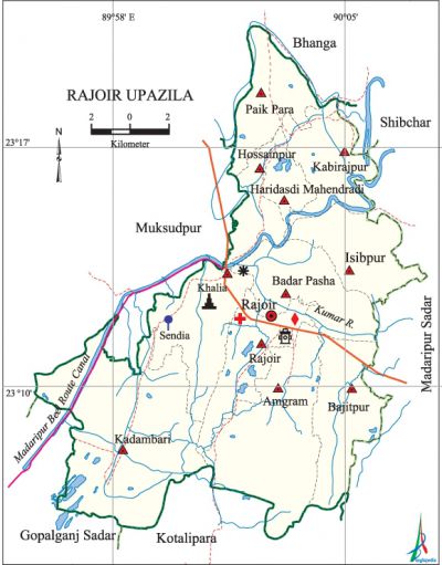
Rajoir Upazila
Rajoir Upazila (madaripur district) area 226.62 sq km, located in between 23°06' and 23°20' north latitudes and in between 89°56' and 90°06' east longitudes. It is bounded by bhanga upazila on the north, kotalipara and gopalganj sadar upazilas on the south, madaripur sadar and shibchar upazilas on the east, muksudpur and Gopalganj Sadar upazilas on the west.
Population Total 218095; male 110233, female 107862; Muslim 146727, Hindu 70393, Buddhist 962 and others 13.
Water bodies Main river: kumar; Madaripur Beel Route Canal, Chandar Beel and Bagier Beel are notable.
Administration Rajoir Thana, now an upazila, was formed in 1914.
| Upazila | ||||||||
| Municipality | Union | Mouza | Village | Population | Density (per sq km) | Literacy rate (%) | ||
| Urban | Rural | Urban | Rural | |||||
|
- |
10 |
93 |
186 |
20302 |
197793 |
962 |
52.4 |
43.5 |
| Upazila Town | ||||||||
|
Area (sq km) |
Mouza |
Population |
Density (per sq km) |
Literacy rate (%) | ||||
|
8.79 |
1 |
20302 |
2310 |
52.39 | ||||
| Union | ||||
| Name of union and GO code | Area (acre) | Population | Literacy rate (%) | |
| Male | Female
| |||
|
Amgram 09 |
8994 |
13171 |
12225 |
42.73 |
|
Isibpur 47 |
4464 |
9843 |
9998 |
44.31 |
|
Kadambari 66 |
10224 |
12840 |
12072 |
52.38 |
|
Kabirajpur 57 |
2219 |
5672 |
5959 |
39.17 |
|
Khalia 76 |
5484 |
17005 |
15556 |
52.01 |
|
Paik Para 85 |
3990 |
9289 |
9751 |
41.51 |
|
Badar Pasha 19 |
5878 |
11486 |
11418 |
40.25 |
|
Bajitpur 28 |
5207 |
9745 |
9552 |
36.27 |
|
Rajoir 95 |
4082 |
11381 |
11051 |
50.66 |
|
Haridasdi Mahendradi |
3424 |
5151 |
5551 |
29.79 |
|
Hossainpur 38 |
2690 |
4650 |
4729 |
32.01 |
Source Bangladesh Population Census 2001, Bangladesh Bureau of Statistics.

Archaeological heritage and relics Sarmangal Mosque, Annapurna Mandir (1765), Khalia Rajaram Mandir (1825), temple of Ganesh Pagal, Patitapaban Sebasrama Mandir, Pranab Math (Bajitpur).
Historical events ambikacharan majumdar of village Sendia in Rajoir upazila formed the first political party of East Bengal in 1881 called 'Faridpur Peoples Association'. In 1918 he established the Faridpur Rajendra College. During the war of liberation the Pak army brutally killed 50 villagers of Sendia. They also conducted mass killing, rape, plundering and set many houses of different villages on fire.
Religious institutions Mosque 370, temple 29, church 2, pagoda 5, tomb 2. Noted religious institutions: Sarmangal Mosque, Kadampur Mosque, Annapunna Mandir (1765), Khalia Rajaram Mandir (1825), temple of Ganesh Pagal, Patitpaban Sebaashrama Mandir, tomb of Syed Ameer Ali, Kamlapur Narauttam Asharama, Pranab Math (Bajitpur).
Literacy rate and educational institutions Average literacy 44.3%; male 49.5%, female 39.1%. Educational institutions: college 6, secondary school 29, primary school 128, kindergarten 6, madrasa 13. Noted educational institutions: Rajoir Degree College (1970), Kadambari Union College (1990), Sheikh Rasel College, Khalia Rajaram Institution (1900), Rajkumar Edward Institution (1902), Amgram High School (1917), Rajoir-Gopalganj Kapali Jubosangho High School (1929), Isibpur High School, Kadambari High School (1942), Aruakandi-Natakhola-Barakhola High School (1963), Haridasdi Mahendradi High School (1965),' Sankherpar High School (1968), Kashimpur Meher Ali High School (1968), Rajoir Girls High School (1968), Tekerhat Popular High School (1970), Hassankandi High School (1971), Chatushpalli High School (1973), Sheed Sardar Shahjahan Girls High School (1986).
Cultural organisations Library 8, club 45, child organization 2, theater group 2, cinema hall 4, women organisation 3, playground 21.
Special attractions Tekerhat Port, Pranab Math (Bajitpur), Kamlapur Narauttam Ashrama.
Newspapers and periodicals Kisholoy (Defunct).
Main sources of income Agriculture 60.68%, non-agricultural labourer 2.33%, industry 1.04%, commerce 19.55%, transport and communication 1.82%, service 4.09%, construction 2.65%, religious service 0.22%, rent and remittance 0.96% and others 6.66%.
Ownership of agricultural land Landowner 69.01%, landless 30.99%; agricultural landowner: urban 48.93% and rural 71.04%.
Main crops Paddy, wheat, jute, sweet potato, sugarcane, pulse, mustard, sesame.
Extinct or nearly extinct crops Kaun, china, barley.
Main fruits Mango, jackfruit, blackberry, star apple, sapodilla, banana, papaya, litchi, date.
Fisheries, dairies and poultries Fishery 31, dairy 2, poultry 155, hatchery 1.
Communication facilities Pucca road 33 km, semi-pucca road 13 km, mud road 325 km; waterway 70 nautical miles.
Extinct or nearly extinct traditional transport Palanquin, duli.
Noted manufactories Rice mill, jute mill, yarn mill, welding factory, aluminium factory, ice factory, bronze ornaments factory.
Cottage industries Blacksmith, potteries, weaving, brass and bell-metal work, ghani (oil mill).
Hats, bazars and fairs Hats and bazars are 22, fairs 8, most noted of which are Rajoir Hat, Amgram Hat, Kadambari Hat, Isibpur Hat, Bajitpur Hat, Kabirajpur Hat, Khalia Hat, Tekerhat, Sendia and Kadambari Samkranti Mela, Khalia Rath Mela, Bajitpur Maghi-Purnima Mela and Ganesh Pagaler Kumba Mela at Kadambari.
Main exports Jute, date molasses, sesame, mustard oil.
'Access to electricity All the unions of the upazila are under rural electrification net-work. However 38.55% of the dwelling households have access to electricity.
Natural resources Pit coal.
Sources of drinking water Tube-well 96.26%, pond 0.77%, tap 0.27% and others 2.70%.
Sanitation 9.71% (rural 7.75% and urban 29.13%) of dwelling households of the upazila use sanitary latrines and 78.47% (rural 80.03% and urban 63.03%) of dwelling households use non-sanitary latrines; 11.21% of households do not have latrine facilities.
Health centres Hospital 1, upazila health centre 6, family planning centre 10, clinic 3.
NGO activities Operationally important NGOs are Village Development Organisation. [Kalyani Rani Chakrabarty]
References Bangladesh Population Census 2001, Bangladesh Bureau of Statistics; Cultural survey report of Rajoir Upazila 2007.
