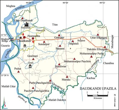
Daudkandi Upazila
Daudkandi Upazila (comilla district) area 314.99 sq km, located in between 23°24' and 23°35' north latitudes and in between 90°41' and 90°53' east longitudes. It is bounded by meghna and titas upazilas on the north, matlab dakshin and kachua upazilas on the south, chandina and muradnagar upazilas on the east, matlab uttar and gazaria upazilas on the west.
Population Total 349910; male 169109, female 180801; Muslim 326959, Hindu 22873, Buddhist 6, Christian 53 and others 19.
Water bodies Main rivers: meghna, gumti; Batakhansi canal is notable.
Administration Daudkandi Thana, now an upazila was formed in 1858.
| Upazila | ||||||||
| Municipality | Union | Mouza | Village | Population | Density (per sq km) | Literacy rate (%) | ||
| Urban | Rural | Urban | Rural | |||||
| 1 | 15 | 169 | 267 | 46256 | 303654 | 1111 | 57.4 | 49.7 |
| Municipality | ||||||||
|
Area |
Ward |
Mahalla |
Population |
Density |
Literacy rate (%) | |||
| 13.18 | 9 | 26 | 46256 | 3510 | 57.4 | |||
| Union | ||||
| Name of union and GO code | Area (acre) | Population | Literacy rate (%) | |
| Male | Female | |||
| Uttar Elliotganj 30 | 3518 | 9288 | 10287 | 50.1 |
| Uttar Daudkandi 21 | 4727 | 9111 | 10229 | 41.5 |
| Goalmari 38 | 5980 | 9644 | 9611 | 61.4 |
| Gauripur 51 | 2217 | 16375 | 16415 | 57.5 |
| Jinglatali 47 | 3112 | 9267 | 9928 | 47.2 |
| Dakshin Elliotganj 34 | 3320 | 11363 | 11846 | 46.9 |
| Paschim Panchgachhia 86 | 3747 | 7327 | 7723 | 52.8 |
| Daulatpur (Purba Panchgachhia) 82 | 5830 | 8290 | 9738 | 44.5 |
| Barapara 90 | 2393 | 9967 | 10878 | 50.1 |
| Biteshwar | 8530 | 8440 | 9328 | 42.0 |
| Padua 85 | 6530 | 7138 | 7500 | 49.3 |
| Maruka 64 | 7443 | 9195 | 10423 | 42.1 |
| Mohammadpur Paschim 73 | 6930 | 10101 | 11041 | 50.7 |
| Mohammadpur Purba 84 | 6540 | 9088 | 10362 | 47.7 |
| Sundalpur 94 | 2650 | 11628 | 12123 | 54.2 |
Source Bangladesh Population Census 2011, Bangladesh Bureau of Statistics.

Archaeological heritage and relics Mosque of Daria Sawdagar (Bara Goali).
War of Liberation On 23 May 1971, the Pak army, in collaboration with the local razakars, killed 11 innocent persons at village Roypura. Besides, they also set many houses of nearby Jinglatali and Harpur villages on fire. Besides, encounters were held between the freedom fighters and the Pak army at Goalmari Bazar in which about 200 Pak soldiers and local rajakars were killed and so were two freedom fighters. There is one mass killing site at Sahapara Bridge on the south of Daudkandi Police Station.
For details: see দাউদকান্দি উপজেলা, বাংলাদেশ মুক্তিযুদ্ধ জ্ঞানকোষ (Encyclopedia of Bangladesh War of Liberation), বাংলাদেশ এশিয়াটিক সোসাইটি, ঢাকা ২০২০, খণ্ড ৪।
Religious institutions Mosque 531, temple 28, tomb 22. Noted religious instituttions : Bania Para Jami Mosque, Baitul Aman Jami Mosque, Changaon Jami Mosque, Kabir Uddin Jami Mosque.
Literacy rate and educational institutions Average literacy 50.7%; male 52.2%, female 49.3%. Educational institutions: college 6, technical training college 1, secondary school 44, primary school 190, nursery school 93, madrasa 32. Noted educational institutions: Elliotganj RB High School (1908), Raipur KC High School (1912), Daudkandi Adarsha High School (1919), Barapara Girls' High School (1919), Chinamura LN High School (1930), Gauripur Subal-Aftab High School (1942).
Newspapers and periodicals Daily: Prantar; weekly: Banglabarta, Monir, Janabarta, Kaldhara, Janatar Prattasha.'
Cultural organisations Library 1, club 116, cinema hall 4, women's organisation 15.
Main crops Paddy, jute, wheat, potato, mustard, futi, khira, watermelon, peanut, pulse, vegetables.
Main fruits Mango, blackberry, guava, plum, banana, orange, papaya, litchi.
Fisheries, dairies and poultries Fishery 80, dairy 97, poultry 233, artificial breeding centre 5.
Communication facilities Pucca road 80 km, semi-pucca road 40 km, mud road 400 km; waterway 75 km.
Extinct or nearly extinct traditional transport Palanquin, bullock cart.
Cottage industries Weaving, jute made products, bamboo work.
Hats, bazars and fairs Hats and bazars are 18, most noted of which are Daudkandi Hat, Gauripur Hat, Elliotganj Hat, Batakhansi Hat, Goalmari Hat, Hasnabad Hat, Alipur Hat, Paler Bazar and Shahidnagar Bazar.
Main exports Jute products, vegetables.
Access to electricity All the unions of the upazila are under rural electrification net-work. However 80.8% of the dwelling households have access to electricity.
Sources of drinking water Tube-well 89.5%, tap 5.0% and others 5.5%.
Sanitation 72.9% of dwelling households of the upazila use sanitary latrines and 23.8% of dwelling households use non-sanitary latrines; 3.3% of households do not have latrine facilities.
Health centres Upazila health complex 1, hospital 3, union health and family welfare centre 15, health centre 9, EPI centre 648, veterinary hospital 1.
NGO activities brac, asa, CCDA, HRD, Uddipan. [AKM Jasim Uddin]
References Bangladesh Population Census 2001 and 2011, Bangladesh Bureau of Statistics; Cultural survey report of Daudkandi Upazila 2007.
