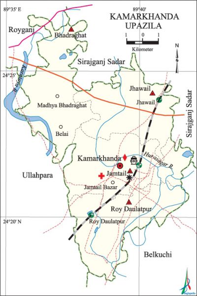
Kamarkhanda Upazila
Kamarkhanda Upazila (sirajganj district) area 90.80 sq km, located in between 24°18' and 24°27' north latitudes and in between 89°35' and 89°42' east longitudes. It is bounded by sirajganj sadar and raiganj upazilas on the north, belkuchi upazila on the south, Belkuchi and Sirajganj Sadar upazilas on the east, ullahpara upazila on the west.
Population Total 138645; male 68411, female 70234; Muslim 133141, Hindu 5494, Christian 7 and others 3.
Water bodies Main rivers: Hurasagar, karatoya.
Administration Kamarkhanda Thana was formed in 1909 and it was turned into an upazila in 1983.
| Upazila | ||||||||
| Municipality | Union | Mouza | Village | Population | Density (per sq km) | Literacy rate (%) | ||
| Urban | Rural | Urban | Rural | |||||
| - | 4 | 55 | 93 | 9913 | 128732 | 1527 | 53.1 | 45.7 |
| Upazila Town | ||||||||
|
Area |
Mouza |
Population |
Density |
Literacy rate (%) | ||||
| 4.01 | 2 | 9913 | 2472 | 53.1 | ||||
| Union | ||||
| Name of union and GO code | Area (acre) | Population | Literacy rate (%) | |
| Male | Female | |||
| Jamtail 38 | 5136 | 19451 | 20041 | 49.9 |
| Jhawail 57 | 5837 | 18358 | 18386 | 42.7 |
| Bhadraghat 19 | 5618 | 14721 | 14930 | 42.9 |
| Roy Daulatpur 76 | 5447 | 15881 | 16877 | 48.8 |
Source Bangladesh Population Census 2011, Bangladesh Bureau of Statistics.
War of Liberation In 1971, Palashdanga Juba Shibir (youth camp) was formed at Kalibari of Bhadraghat Union. During the war of liberation this Juba Shibir played a remarkable role in encounters against the Pak army at different places. Freedom fighters had a fierce fight with the Pak army at Bhadraghat on 17 June in which 11 Pakistani soldiers were killed and 10 others were wounded. Freedom fighters had another fight with Pakistani soldiers at the area near Jhaoil Bridge.
For details: see কামারখন্দ উপজেলা, বাংলাদেশ মুক্তিযুদ্ধ জ্ঞানকোষ (Encyclopedia of Bangladesh War of Liberation), বাংলাদেশ এশিয়াটিক সোসাইটি, ঢাকা ২০২০, খণ্ড ২।
Religious institutions Mosque 20, temple 8.

Literacy rate and educational institutions Average literacy 46.2%; male 48.9%, female 43.7%. Educational institutions: college 7, secondary school 22, primary school 77, madrasa 11. Noted educational institutions: Haji Korop Ali Memorial Degree College, Kamarkhanda Mahila Degree College, Dhopakandhi Bilateral High School, Dhopakandhi Pilot Girls' High School, Kamarkhanda Senior Fazil Madrasa.
Cultural organisations Public library 1.
Main sources of income Agriculture 47.06%, non-agricultural labourer 4%, industry 1.14%, commerce 16.57%, transport and communication 3.87%, service 8.70%, construction 0.87%, religious service 0.27%, rent and remittance 0.26% and others 17.26%.
Ownership of agricultural land Landowner 57.74%, landless 42.26%; agricultural landowner: urban 39.18% and rural 59.17%.'
Main crops Paddy, wheat, jute, sugarcane, mustard, vegetables.
Extinct or nearly extinct crops Varieties of pulse, shone, kaun.
Main fruits Mango, blackberry, jackfruit, banana, papaya, plum.
Fisheries, dairies and poultries The upazila has a number of dairies and artificial breeding centre.
Communication facilities Roads: pucca 94 km, semi-pucca 5 km, mud road 72 km; railway 14 km.
Extinct or nearly extinct traditional transport Palanquin, horse carriage, bullock cart.
Noted manufactories Rice mill, ice factory.
Cottage industries Weaving, potteries, embroidery, bamboo work, cane work.
Communication facilities Pucca road 55 km, mud road 208 km; railway 10 km; waterway 4.58 nautical miles. Bridge 85, culvert 97, railstation 1.
Hats, bazars and fairs Hats and bazars are 16, fairs 4, most noted of which are Jamtail Bazar, Kamarkhanda Bazar, Bhadraghat Bazar; Baradhul Hat, 'Balarampur Hat.
Main exports Mustard seed, molasses, vegetables, bamboo and cane products.
Access to electricity All the unions of the upazila are under rural electrification net-work. However 56.2% of the dwelling households have access to electricity.
Sources of drinking water Tube-well 97.7%, tap 0.8% and others 1.5%. The presence of arsenic in an intolerable level has been detected in 1598 shallow tube-well water of the upazila. About 25 patients with arsenic contaminated disease, has been detected.
Sanitation 74.4% of dwelling households of the upazila use sanitary latrines and 22.1% of dwelling households use non-sanitary latrines; 3.5% of households do not have latrine facilities.
Health centres Upazila health complex 1, family welfare centre 4, satellite clinic 2.
Natural disasters The earthquakes of 1885 and 1897 caused heavy damages to pucca houses and other properties of the upazila. Besides, a large number of people of the upazila were victims of the famine of 1943.
NGO activities Operationally important NGOs are brac, asa. [Sufia Parveen]
References Bangladesh Population Census 2001 and 2011, Bangladesh Bureau of Statistics; Cultural survey report of Kamarkhanda Upazila 2007.
