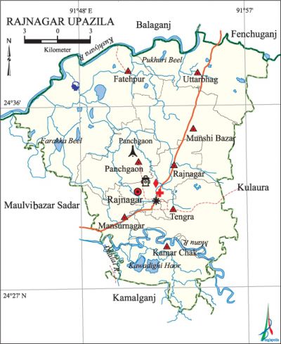
Rajnagar Upazila
Rajnagar Upazila (maulvibazar district) area 338.15 sq km, located in between 24°26' and 24°39' north latitudes and in between 91°44' and 91°58' east longitudes. It is bounded by balaganj and fenchuganj upazilas on the north, kamalganj upazila on the south, kulaura upazila on the east, maulvibazar sadar upazila on the west.
Population Population Total 232666; male 113149, female 119517; Muslim 180570, Hindu 51867, Buddhist 4, Christian 133 and others 92. Indigenous community such as khasia belongs to this upazila.
Water bodies Main rivers: manu, Dhalai, kushiyara; Kawadighi Haor; Farakka and Pukhuri Beels are notable.
Administration Rajnagar Thana was formed in 1922 and it was turned into an upazila in 1984.
| Upazila | ||||||||
| Municipality | Union | Mouza | Village | Population | Density (per sq km) | Literacy rate (%) | ||
| Urban | Rural | Urban | Rural | |||||
| - | 8 | 147 | 267 | 14134 | 218532 | 688 | 46.5 | 48.8 |
| Upazila Town | ||||||||
|
Area (sq km) |
Mouza |
Population |
Density (per sq km) |
Literacy rate (%) | ||||
| 8.79 | 4 | 14134 | 1608 | 46.5 | ||||
| Union | ||||
| Name of union and GO code | Area (acre) | Population | Literacy rate (%) | |
| Male | Female | |||
| Uttarbhag 84 | 14538 | 18573 | 19291 | 46.8 |
| Kamar Chak 21 | 9053 | 12158 | 13672 | 44.8 |
| Tengra 73 | 11062 | 14327 | 14851 | 36.9 |
| Panchgaon 52 | 7177 | 11597 | 12283 | 50.3 |
| Fatehpur 10 | 21011 | 14130 | 15126 | 58.0 |
| Mansurnagar 31 | 5200 | 12440 | 13092 | 49.5 |
| Munshi Bazar 42 | 12497 | 16064 | 16891 | 51.1 |
| Rajnagar 63 | 5881 | 13860 | 14311 | 51.8 |
Source Bangladesh Population Census 2011, Bangladesh Bureau of Statistics.

Archaeological heritage and relics Copperplate of c. 930 AD at village Paschimbagh, Tengu Bazar Mandir, Canon 'Jahankosa' made by Janardhan Karmakar.
War of Liberation In 1971 the Pak army conducted mass killing and heavy plundering in the upazila; they also set many houses on fire. The Pak army killed 15 innocent persons of Dhar Bari and Shahaji Bari under Munshi Bazar union. On 14 May they also conducted mass killing and set many houses of Uttarbhagh, Chatura, Pancheswar and Rajnagar villages on fire. During the war of liberation 11 freedom fighters were killed in a frontal encounter with the Pak army. On 4 December a group of 30 freedom fighters took control of a Pak army camp located at Udna Tea Garden. Rajnagar was liberated on 6 December. There are mass graves at 2 places (Panchgaon and Munshi Bazar) of the upazila; a memorial monument has been built at Munshi Bazar.
For details: see রাজনগর উপজেলা, বাংলাদেশ মুক্তিযুদ্ধ জ্ঞানকোষ (Encyclopedia of Bangladesh War of Liberation), বাংলাদেশ এশিয়াটিক সোসাইটি, ঢাকা ২০২০, খণ্ড ৯।
Religious institutions Mosque 310, temple 51, tomb 10, sacred place 2. Noted religious institutions: Panchgaon Durga Mandir, Panishail Akhra and Mandir, Rajar Mandir at Tengra.
Literacy rate and educational institutions Average literacy 48.6%; male 49.1%, female 48.2%. Educational institutions: college 2, secondary school 13, primary school 142, satellite school 15, madrasa 18. Noted educational institutions: Rajnagar Degree College (1973), Moulana Mufazzal Hossain Mohila College (1994), Rajnagar Porteous High School (1893), Meherunnessa Girls' High School (1965), Panchgaon High School, Kandigaon High School, Janata High School, Eka Santosh Government Primary School (1880), Ghargaon Hedaytul Islam Title Madrasa (1926), Rajnagar DS Fazil Madrasa (1973).
Newspapers and periodicals Weekly: Rajkantha; irregular and defunct: Shilpatari, Mukti Sangram, Manukuler Kagaz, Dip Shikha, Rajnagar Barta, Maral.
Cultural organisations Library 3, club 50, jatra party 4, playground 6.
Tourist spots Parbatpur Tea Garden, Karimpur Tea Garden, Lohauni Tea Garden, Ita Tea Garden, Kamla Rani Dighi and Dewan Dighi.
Main sources of income Agriculture 51.61%, non-agricultural labourer 14.07%, commerce 8.16%, transport and communication 1.55%, service 3.55%, construction 1.23%, religious service 0.34%, rent and remittance 5.47% and others 14.02%.
Ownership of agricultural land Landowner 45.62%, landless 54.38%; agricultural landowner: urban 44.04% and rural 45.72%.'
Main crops Paddy, tea, potato, mustard, ginger, turmeric, vegetables.
Extinct or nearly extinct crops Sesame, sweet potato, arahar.
Main fruits Mango, jackfruit, pineapple, blackberry, banana, papaya.
Fisheries, dairies and poultries Fishery 11, dairy 25, poultry 32.
Communication facilities Pucca road 140 km, semi-pucca road 30 km, mud road 278 km.
Extinct or nearly extinct traditional transport Palanquin, horse carriage, bullock cart.
Noted manufactories Rice mill, pulse mill, Tea processing factory, rubber factory, Attar (perfume) factory.
Cottage industries Goldsmith, blacksmith, potteries, weaving, shitalpati, bamboo work, cane work.
Hats, bazars and fairs Hats and bazars are 32, fairs 5, most noted of which are Tengra Bazar, Munshi Bazar, Rajnagar Bazar, Haripasha Bazar, Sarkar Bazar, Azad Bazar, Rajkrishnapur Bazar, Bhangar Hat, Bager Mela, Baruni Mela and Muharram Mela at Naiyatila.
Main exports Tea, pineapple, shitalpati, attar.
Access to electricity All the unions of the upazila are under rural electrification net-work. However 44.9% of the dwelling households have access to electricity.
Sources of drinking water Tube-well 82.6%, tap 1.3% and others 16.1%.
Sanitation 51.1% of dwelling households of the upazila use sanitary latrines and 41.1% of dwelling households use non-sanitary latrines; 7.8% of households do not have latrine facilities.
Health centres Upazila health centre 1, family planning and satellite centre 1, rural health centre 2.
NGO activities Operationally important NGOs are brac, asa, BUP, HEED Bangladesh. [Shah Md. Muizur Rahman]
References Bangladesh Population Census 2001 and 2011, Bangladesh Bureau of Statistics; Cultural survey report of Rajnagar Upazila 2007.
