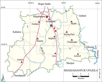
Shahjahanpur Upazila
Shahjahanpur Upazila (bogra district) area 221.69 sq km, located in between 24°41' and 24°50' north latitudes and in between 89°16' and 89°29' east longitudes. It is bounded by bogra sadar upazila on the north, sherpur upazila on the south, gabtali and dhunat upazilas on the east, kahaloo and nandigram upazilas on the west.
Population Total 289804; male 149458, female 140346; Muslim 278139, Hindu 11557, Buddhist 42, Christian 41 and others 25.
Water bodies Main rivers: Bhadai, Bangali.
Administration Shahjahanpur upazila was formed on 21 January 2003.
| Upazila | ||||||||
| Municipality | Union | Mouza | Village | Population | Density (per sq km) | Literacy rate (%) | ||
| Urban | Rural | Urban | Rural | |||||
| - | 9 | 120 | 166 | 62140 | 227664 | 1307 | 73.6 | 53.3 |
| Municipality | ||||||||
| Area (sq km) |
Ward | Mahalla | Population | Density (per sq km) |
Literacy rate (%) | |||
| 22.63 | 1+2 (Part) | 16 | 62140 | 2746 | 73.6 | |||
| Union | ||||
| Name of union and GO code | Area (acre) | Population | Literacy rate (%) | |
| Male | Female | |||
| Aria 17 | 5829 | 18710 | 18710 | 65.8 |
| Amrool 16 | 6106 | 11633 | 11633 | 47.7 |
| Asekpur 18 | 6301 | 14296 | 14296 | 57.5 |
| Khotta Para 43 | 3752 | 11589 | 11259 | 48.7 |
| Kharna 38 | 9033 | 14064 | 14108 | 47.9 |
| Gohail 30 | 8428 | 13047 | 13047 | 43.7 |
| Chopinagar 19 | 4048 | 11237 | 11237 | 51.1 |
| Majhira 56 | 2264 | 10435 | 10017 | 62.1 |
| Madla 51 | 3174 | 9360 | 9161 | 49.0 |
| Sultanganj 90 | 5829 | 18710 | 18710 | 65.8 |
Source Bangladesh Population Census 2011, Bangladesh Bureau of Statistics.

Archaeological heritage and relics Khadash Rajbari (Gohail), three doomed Gohail Jami Mosque built by Pandit Shah, Buddhist Math (Bergari), Jami Mosque (Ullah Akanda Para).
War of Liberation On 23 April the Pak army entered the Bogra Town and in collaboration with the local Biharis, they conducted killing and tortured and burnt settlements. On 11 November the Pak army and razakars captured 21 persons from Thanthania Khandar area and later killed 14 of them by gun shot at a place called Babur Puklur, whre there is a mass grave.
For details: see শাজাহানপুর উপজেলা, বাংলাদেশ মুক্তিযুদ্ধ জ্ঞানকোষ (Encyclopedia of Bangladesh War of Liberation), বাংলাদেশ এশিয়াটিক সোসাইটি, ঢাকা ২০২০, খণ্ড ৯।
Religious institutions Mosque 371, temple 45, math 1.Noted Religious institutions: Gohail Jami Mosque, Jami Mosque, Buddhist Math.
Literacy rate and educational institutions Average literacy 57.7%, male 60.5%, female 54.7%. Educational institutions: BEd college 1, agricultural college 1, technical institution 3, college 5, secondary school 31, primary school 121, madrasa 62. Noted educational institutions: Cantonment Public School and College (1979), Cantonment Board High School and College (1986), Ranirhat Technical College (2000), Khotta Para Siddiqua Senior Fazil Madrasa (1905), Domonpur Amiya Fazil Madrasa (1908), Jora Nazmul Ulm Fazil Madrasa (1910), Behigram ADU Central Fazil Madrasa (1921).
Cultural organisations Library 6, cinema hall 2.
Special attractions 'Bijayangan' (War of Liberation Museum), Park on the triangular corner on the Dhaka Natore Road.
Main sources of income Agriculture 55.48%, non-agricultural labourer 2.52%, industry 1.37%, commerce 13.01%, transport and communication 6.49%, service 10.98%, construction 2.50%, religious service 0.17%, rent and remittance 0.39% and others 7.09%.
Ownership of agricultural land Landowner 57.35%, landless 42.65%.
Main crops paddy, pulses, potato, corn, vegetables.
Fisheries, dairies and poultries Dairy 62, poultry 65, artificial breeding centre 3.
Communication facilities Pucca road 102.25 km, semi pucca road 3.78 km, mud road 791.97 km.
Manufactories Metal works, furniture factory.
Cottage industries Weaving, pottery, wood work, embroidery, bamboo and cane work.
Hats, bazars and fairs Hats and bazars are 9, fairs 3, most noted of which are Durlagari Hat, Sultanganj Hat, Ranir Hat, Nagar Hat, Domon Pukur Hat, Madla Bazar, Atia Bazar, Majhira Bazar, Majhira Mandir Mela (held on the Krishnapakkha of 30th day of Falgun, BS), Jamanna Mela at village Aria, Demajani Mela in Amrool union.
Access to electricity All the unions of the upazila are under rural electrification network. However 66.9% of the dwelling households have access to electricity.
Sources of drinking water Tube-well 90.6%, tap 7.9% and others 1.5%. The presence of arsenic has been detected in the shallow tube well water of the upazila.
Sanitation 71.8% of dwelling households of the upazila use sanitary latrines and 22.6% of dwelling households use non-sanitary latrines; 5.6% of households do not have latrine facilities.
Health centres Upazila health centre 1, union satellite clinic 2, maternity and child welfare centre 10, community clinic 30.
Natural disasters Many people were victims of the floods of 1955, 1969, 1970, 1984 and the cyclone of 1864. These natural disasters also caused heavy damages to settlements, crops and livestock of the upazila.
NGO activities Operationally important NGOs are Palli Unnayan Prakalpa, Grameen Unnayan Prakalpa. [AKM Jasimuddin]
References Bangladesh Population Census 2001 and 2011, Bangladesh Bureau of Statistics; Cultural survey report of Shahjahanpur Upazila 2007.
