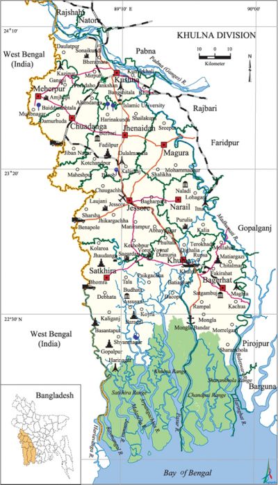
Khulna Division
Khulna Division area 21643.30 sq km, located in between 21°60' and 24°13' north latitudes and in between 88°34' and 89°58' east longitudes. It is bounded by rajshahi, natore and pabna districts on the north, bay of bengal on the south, rajbari, faridpur, gopalganj, pirojpur and barguna districts on the east, west bengal state of India on the west. The sundarbans is located in this division covering southern parts of Satkhira, Khulna and Bagerhat districts.
Population Total 14705229; male 51.05%, female 48.95%; Muslim 82.87%, Hindu 16.45% and others 0.68%.
Water bodies Main rivers: ganges (Padma), gorai-madhumati, jamuna, ichamati, kobadak, shibsa, kumar, rupsa-pasur, bhairab, chitra, Baleswari, Malancha, Haringhat, Arpangachhia, Raymangal and Mathabhanga.
| Division | ||||||||||
| Area (sq km) |
City corporation | District | Upazila | Paurasabha | Union | Ward | Population | Density (per sq km) |
Literacy rate (%) | |
| Urban | Rural | |||||||||
|
21643.30 |
1 |
10 |
59 |
28 |
270 |
540 |
3042664 |
11662565 |
746 |
47.14 |
| City corporation | ||||||
| City corporation | Metropolitan thana | Ward and Union | Mahalla and Mouza | Population | Density (per sq km) |
Literacy rate (%) |
|
1 |
5 |
35 |
184 |
884445 |
16244 |
70.42 |
| Metropolitan thana | ||||||
| Metropolitan thana | Area (sq km) | Ward and Union | Mahalla and Mouza | Population | Density (per sq km) |
Literacy rate (%) |
| Kotwali 51 |
9.45 |
9 |
63 |
250651 |
26524 |
72.86 |
| Khan Jahan Ali 48 |
28.95 |
1+1 (Part) |
4 |
108317 |
3742 |
71.30 |
| Khalishpur 45 |
11.47 |
8+2 (Part) |
41 |
235018 |
20490 |
73.72 |
| Daulatpur 21 |
11.81 |
6+1 (Part) |
34 |
118380 |
10024 |
66.85 |
| Sonadanga 85 |
8.42 |
7 |
42 |
172079 |
20437 |
68.91 |
| Other information | |||||||||||
|
Name of District |
Area (sq km) | Upazila | Municipality | Ward | Mahalla | Union | Mouza | Village | Population | Density (per sq km) |
Literacy rate (%) |
| Khulna |
4394.46 |
9 |
2 |
33 |
181 |
67 |
747 |
1101 |
2378971 |
541 |
57.81 |
| Jhenaidah |
1949.62 |
6 |
5 |
45 |
137 |
67 |
945 |
1150 |
1579490 |
810 |
44.70 |
| Magura |
406.50 |
4 |
1 |
9 |
61 |
13 |
222 |
236 |
331494 |
815 |
45.80 |
| Kushtia |
1621.15 |
6 |
4 |
39 |
77 |
61 |
711 |
978 |
1740155 |
1073 |
40.40 |
| Jessore |
2570.42 |
8 |
4 |
36 |
122 |
92 |
1329 |
1434 |
2471554 |
962 |
51.29 |
| Bagerhat |
3959.11 |
9 |
3 |
27 |
56 |
75 |
720 |
1031 |
1549031 |
391 |
58.70 |
| Chuadanga |
1177.40 |
4 |
4 |
36 |
113 |
31 |
364 |
514 |
1007130 |
855 |
40.88 |
| Meherpur |
716.08 |
3 |
1 |
9 |
72 |
18 |
190 |
278 |
591436 |
826 |
37.80 |
| Narial |
990.23 |
3 |
2 |
18 |
43 |
37 |
445 |
651 |
698447 |
705 |
48.56 |
| Satkhira |
3858.33 |
7 |
2 |
18 |
40 |
79 |
953 |
1435 |
1864704 |
483 |
45.52 |
Source Bangladesh Population Census 2001, Bangladesh Bureau of Statistics.

Administration Khulna Division was formed in 1960. Khulna Paurasabha was declared on 12 December 1884. It was up graded into a Municipal Corporation on 12 December 1984; Khulna City Corporation was declared on 6 August 1990.
Religious institutions Mosque 20737, temple 2059, church 47, tomb 78.
Literacy rate and educational institutions Average literacy 46.94%; male 50.87%, female 42.80%. Educational institutions: university 7, college 310, medical college 2, law college 4, teachers training college 14, secondary school 1984, primary school 19112, kindergarten 77, satellite school 303, madrasa 2041, others 120. Noted educational institutions: university of khulna, khulna university of engineering and technology, Khulna Medical College, Brajalal College, Khulna Public College, MA Majid College, MM College, Jhenaidah Cadet College, Michael Madhusudan University College, Jessore Zila School (1838), Magura Government Boys' High School, Narail Boys' High School (1854), Naldha Secondary School (1895), Baraipara Primary School (1850), Angra Government Primary School (1918), Pragpur Government Primary School (1905), Shahbad Majidia Alia Madrasa (1950).
Main sources of income Agriculture 56.56%, non-agricultural labourer 4.04%, industry 1.72%, commerce 15.20%, transport and communication 3.47%, service 4.77%, construction 4.09%, religious service 0.51%, rent and remittance 0.5% and others 9.14%.
Health centres Hospital 17, clinic 54, upazila health complex 75, family planning centre 183, satellite clinic 191, union health centre 148, eye hospital 8, diabetic hospital 4, maternity and child welfare centre 14, chest disease hospital 3, mission hospital 5, veterinary hospital 7. [Sajahan Miah]
References Bangladesh Population Census 2001, Bangladesh Bureau of Statistics; Cultural survey report of districts and upazilas of Khulna Division 2007.
