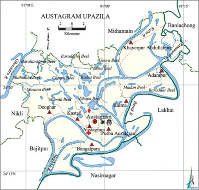
Austagram Upazila
Austagram Upazila (kishoreganj district) area 355.53 sq km, located in between 24°13' and 24°27' north latitudes and in between 90°59' and 90°15' east longitudes. It is bounded by mithamain upazila on the north, nasirnagar upazila on the south, lakhai upazila on the east, bajitpur upazila on the west.
Population Total 152523; male 75265, female 77258; Muslim 132000, Hindu 20494, Christian 9 and others 20.
Water bodies Main rivers: meghna, barak, Kalni, Ghorautra; noted beels: Padma, Topa, Bandra, Chamil, Mamda, Matihata, Dhopa, Mojana, Balian and Monkhola beel.
Administration Austagram Thana was formed in 1905 and it was turned into an upazila in 1983.
| Upazila | ||||||||
| Municipality | Union | Mouza | Village | Population | Density (per sq km) | Literacy rate (%) | ||
| Urban | Rural | Urban | Rural | |||||
| - | 8 | 61 | 72 | 17400 | 135123 | 429 | 36.1 | 31.5 |
| Upazila Town | ||||||||
|
Area (sq km) |
Mouza |
Population |
Density (per sq km) |
Literacy rate (%) | ||||
| 2.15 | 1 | 17400 | 8093 | 36.1 | ||||
| Union | ||||
| Name of union and GO code | Area (acre) | Papulation | Literacy rate (%) | |
| Male | Female | |||
| Adampur 11 | 9386 | 11880 | 12302 | 32.9 |
| Austagram 23 | 8791 | 9935 | 10449 | 35.6 |
| Kalma 59 | 8286 | 5403 | 5713 | 36.5 |
| Kastail 71 | 10689 | 7366 | 7663 | 26.1 |
| Khayerpur Abdullahpur 83 | 15397 | 15427 | 15409 | 27.8 |
| Deoghar 47 | 11773 | 9379 | 9742 | 30.6 |
| East Austagram 91 | 3359 | 7847 | 8034 | 37.3 |
| Bangal Para 35 | 6559 | 8028 | 7946 | 32.8 |
Source Bangladesh Population Census 2011, Bangladesh Bureau of Statistics.

Archaeological heritage and relics Stone Mosque (c. 1446, Kastail), Kutub Mosque (c. 16 century).
War of Liberation On 3 September 1971 the Pak army, in collaboration with the rajakars brutally killed 35 members of the Hindu community at village Ikardia. On 5 September they also killed 25 members of the Hindu community at village Savianagar. Freedom fighters had encounters with Pakistani soldiers in the upazila on 3 occasions.
For details: see অষ্টগ্রাম উপজেলা, বাংলাদেশ মুক্তিযুদ্ধ জ্ঞানকোষ (Encyclopedia of Bangladesh War of Liberation), বাংলাদেশ এশিয়াটিক সোসাইটি, ঢাকা ২০২০, খণ্ড ১।
Religious institutions Mosque 82, temple 13, tomb 12, Akhra 21.
Literacy rate and educational institutions Average literacy 32.0%; male 34.0% female 30.1%.
Newspapers and Periodicals Magazines: Shubechha, Surjatopa and Anirban.
Cultural organizations Library 1,' officers' club 1, playground 30.
Main sources of income Agriculture 82.40%, non-agricultural labourer 2.52%, industry 0.27%, commerce 7.52%, transport and communication 0.29%, service 1.91%, construction 0.31%, religious service 0.24%, rent and remittance 0.04% and others 4.50%.
Ownership of agricultural land Landowner 66.18%, landless 33.82%; ownership of agricultural land: urban 56.38% urban 67.51%.
Main crops Paddy, potato, mustard,' peanut, garlic, onion, chilli, turmeric, coriander.
Extinct or nearly extinct crops Jute.
Main fruits Mango, jackfruit, banana, blackberry, papaya.
Communication facilities Roads: pucca road 25 km, semi-pucca road 15 km and mud road 268 km; waterway 23.814 km.
Extinct or nearly extinct Traditional transport palanquin, horse carriage and bullock cart.
Hats, bazars and fairs The most noted hats and bazars are Austagram, Purbo Austagram, Sharifanagar, Kastail, Bangal Para, Adampur, Kalma, Khayerpur Abdullahpur and Chhaudamadal Mela at Bangal Para (largest mela of the bhati region).
Main exports Paddy, potato, peanut, banana, papaya.
Access to electricity All the unions of this Upazila are under electricity net-work; however, 43.7% dwelling households have access to electricity.
Sources of drinking water Tube-well 92.8%, tap 0.1% and others 7.1%.
Sanitation 37.1% of dwelling households of the upazila use sanitary latrines and 54.4% of dwelling houses use non-sanitary latrines; 8.5% of households do not have latrine facilities.
Health centres Upazila health complex 1, union health and family planning centre 7, rural health centre 1.
NGO activities brac, proshika, ICDC, Ganaunnyan, Bandhon Society, Chetana. [Enayet Sobhan]
References Bangladesh PopulaAtion Census 2001 and 2011, Bangladesh Bureau of Statistics; Cultural survey report of Austagram Upazila 2007.
