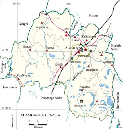
Alamdanga Upazila
Alamdanga Upazila (chuadanga district) area 364.66 sq km, located in between 23°37' and 23°50' north latitudes and in between 88°47' and 89°00' east longitudes. It is bounded by mirpur (kustia) and gangni upazilas on the north, harinakunda and kustia sadar upazilas on the east, chuadanga sadar and damurhuda upazilas on the south, meherpur sadar and gangni upazilas on the west.
Population Total 345922; male 172932, female 172990; Muslim 336715, Hindu 9050 and others 157.
Water bodies Main rivers: kumar and nabaganga.
Administration Alamdanga Thana was turned into an upazila in 1982.
| Upazila | ||||||||
| Municipality | Union | Mouza | Village | Population | Density (per sq km) | Literacy rate (%) | ||
| Urban | Rural | Urban | Rural | |||||
| 1 | 14 | 123 | 204 | 78372 | 267550 | 949 | 49.54 (2001) | 43.4 |
| Municipality | ||||||||
| Area (sq km) |
Ward | Mahalla | Population | Density (per sq km) |
Literacy rate (%) | |||
| 9.60 (2001) | 9 | 19 | 32048 | 2817 (2001) | 63.1 | |||
| Upazila Town | ||||
| Area (sq km) | Mouza | Population | Density (per sq km) | Literacy rate (%) |
| 46.97 (2001) | 14 | 46324 | 897 (2001) | 46.5 |
| Union | ||||||||
| Name of union and GO code | Area (acre) | Population | Literacy rate (%) | |||||
| Male | Female | |||||||
| Kalidaspur 51 | 4937 | 11595 | 11710 | 42.0 | ||||
| Kumari 87 | 5015 | 9189 | 9057 | 44.3 | ||||
| Khadimpur 71 | 6023 | 10117 | 9738 | 56.4 | ||||
| Khaskara 79 | 7128 | 11329 | 11536 | 40.1 | ||||
| Gangni 39 | 6232 | 12280 | 11762 | 55.9 | ||||
| Chithla 27 | 6580 | 11340 | 11273 | 54.1 | ||||
| Jamjami 55 | 5408 | 9185 | 9313 | 40.3 | ||||
| Jehala 63 | 5342 | 11168 | 11118 | 44.4 | ||||
| Dauki 31 | 6031 | 9170 | 9561 | 39.0 | ||||
| Nagdaha 94 | 11710 | 15974 | 16194 | 36.6 | ||||
| Baradi 15 | 5303 | 9814 | 9769 | 41.8 | ||||
| Belgachhi 13 | 4669 | 7162 | 7264 | 39.8 | ||||
| Bhangabaria 23 | 6924 | 13949 | 13765 | 41.5 | ||||
| Hardi 47 | 6439 | 14886 | 14656 | 40.4 | ||||
Source Bangladesh Population Census 2001 and 2011, Bangladesh Bureau of Statistics.
Archaeological heritage and relics 'Gholdari Mosque (Nagdaha), Teyorbila Mosque (Khaskarra), Jamjami Mosque, Bademaju Mosque, Sonatanpur Mandir and Gholdari Nilkuthi.
Historical events In eighteenth century the peasants of Alamdanga revolted against indigo plantation. Maheshchandra Chatterjee united the peasants and led armed revolution against the indigo planters and resisted them.
War of Liberation During the war of liberation a number of rajakars and Pak soilders were killed or wounded in encounters with the freedom fighters in Baliapur and Benagari villages. Freedom fighters had encounters with Pak army at Shukcha-Bajitpur, Hatboalia, Enayetpur, Baradi, Nimoniganj, Paikpara, kakiladaha and some other places of the upazila. A mass grave has been discovered on the bank of GK Canal adjacent to the Alamdanga railway station.
For details: see আলমডাঙ্গা উপজেলা, বাংলাদেশ মুক্তিযুদ্ধ জ্ঞানকোষ (Encyclopedia of Bangladesh War of Liberation), বাংলাদেশ এশিয়াটিক সোসাইটি, ঢাকা ২০২০, খণ্ড ১।

Religious institutions Mosque 228, temple 4, church 4.
Literacy rate and educational institutions Average literacy 45.7%; Male 47.1%, female 44.3%. Noted educational institutions: Alamdanga College (1965), M S Joha Degree College (1994), Alamdanga Multilateral (Pilot) Secondary School (1914), Hat Boalia Secondary School (1925), Munshiganj Academy (1944).
Cultural organizations Library 2, club 18, theatre group 7, cinema hall 7.
Main source sources of income' Agriculture 41.76%, non-agriculture labourer 27.35%, industry 0.84%, business 12.54%, service 3.78%, construction 0.87%, religious service' 0.17%, rent and remittance 0.43%, transport and communication 2.89% and others 6.01%.
Ownership of agricultural land Landowner 62.44%, landless 37.56%; agricultural landowner: urban 50.12%, rural 65.93%.
Main crops Paddy, jute, wheat, sugarcane, pulse, potato, corn, gram, tobacco, betel nut, betel leaf.
Extinct and nearly extinct crops' Sesame, mustard, indigo.
Main fruits Mango, jackfruit, papaya, banana.
Fisheries, dairies and poultries Fishery 3, dairy 4, poultry 17.
Communication facilities Pucca road 305 km, semi pucca road 47 km, mud road 484 km; railways 19 km; waterway 10 km.
Extinct or nearly extinct traditional transport Palanquin, boat, horse carriage.
Noted manufactories Sugar mill, flour mill, rice mill, threshed rice (chira) mill, saw mill, ice factory.
Cottage industries Weaving, blacksmith, potteries, bamboo work, cane work.
Hats, bazars and fairs Total hats bazars are 24, fairs 2, most noted of which are Munshiganj Hat, Alamdanga Hat, Asmankhali Hat, Gokulkhali Hat, Boalia Hat and Baul Mela (Gopinathpur) and Poush Samkranti Mela.
''Main exports Tobacco, betel leaf, betel nut, jute.
Access to electricity All the wards and unions of this upazila are under electricity net-work. However 59.7% of the dwelling households only have access to electricity.
Sources of drinking water Tube-well 97.4%, tap 0.6% and others 2.0%. The level of arsenic contamination in the tube-well water is 34.94% which is 34.89% higher than normal level. As a result a lot of people are suffering from many diseases including skin disease.
Sanitation 39.9% of dwelling households of the upazila use sanitary latrines and 52.8% of dwelling houses use non-sanitary latrines; 7.3% of households do not have sanitation facilities.
Heath centres Upazila health complex 1, health and family welfare centre 14.
NGO activities Operationally important NGOs are brac, asa, care, Wave Foundation, Sajaag, Sreejani. [Md Faysal Kibria]
References Bangladesh Population Census 2001 and 2011, Bangladesh Bureau of Statistics; Cultural Survey Report of Alamdanga Upazila 2007.
