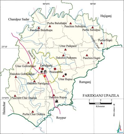
Faridganj Upazila
Faridganj Upazila (chandpur district) area 232.22 sq km, located in between 23°03' and 23°14' north latitudes and in between 90°41' and 90°53' east longitudes. It is bounded by chandpur sadar and hajiganj upazilas on the north, raipur upazila on the south, ramganj upazila on the east, haimchar and Chandpur Sadar upazilas on the west.
Population Total 396683; male 182360, female 214323; Muslim 377886, Hindu 18630, Buddhist 5, Christian 73 and others 89.
Water bodies dakatia river and Guptir Beel are notable.
Administration Faridganj Thana, now an upazila, was formed on 7 October 1918.'
| Upazila | ||||||||
| Municipality | Union | Mouza | Village | Population | Density (per sq km) | Literacy rate (%) | ||
| Urban | Rural | Urban | Rural | |||||
| 1 | 15 | 161 | 161 | 35090 | 361593 | 1708 | 60.1 | 57.9 |
| Municipality | ||||||||
|
Area |
Ward |
Mahalla |
Population |
Density |
Literacy rate (%) | |||
| 19.69 | 9 | 21 | 35090 | 1782 | 60.1 | |||
| Union | ||||
| Name of union and GO code | Area (acre) | Population | Literacy rate (%) | |
| Male | Female | |||
| Uttar Gobindapur 41 | 3828 | 11169 | 13417 | 52.2 |
| Uttar Paikpara 65 | 3933 | 11322 | 14029 | 64.3 |
| Uttar Rupsa 77 | 4004 | 13237 | 15631 | 60.3 |
| Dakshin Gobindapur 47 | 2894 | 11936 | 14269 | 53.2 |
| Dakshin Paikpara 71 | 3115 | 11198 | 13452 | 61.0 |
| Dakshin Faridganj 35 | 3986 | 9254 | 11052 | 54.7 |
| Dakshin Rupsa 83 | 2858 | 10340 | 12183 | 60.7 |
| Paschim Gupti 59 | 2669 | 9719 | 11591 | 65.5 |
| Purba Gupti 53 | 3571 | 10457 | 12083 | 57.8 |
| Paschim Char Dukhia 23 | 2778 | 9144 | 11385 | 51.6 |
| Purba Char Dukhia 17 | 4041 | 11290 | 13734 | 52.1 |
| Paschim Baluthupa 11 | 4107 | 11877 | 12816 | 54.5 |
| Purba Baluthupa 13 | 3969 | 12679 | 15101 | 59.7 |
| Paschim Subidpur 95 | 3560 | 11091 | 12413 | 59.9 |
| Purba Subidpur 89 | 3965 | 11021 | 12703 | 60.1 |
Source Bangladesh Population Census 2011, Bangladesh Bureau of Statistics.

Archaeological heritage and relics Neelkuthi (indigo factory) at Sahebganj, Math at Lohagara, Rupsa Zamindar Bari, Rupsa Mosque.
War of Liberation During the War of Liberation in 1971, freedom fighters had encounters with Pak army at Kamalpur, Badara Bazar, Paikpara, Rupsha Bazar, Gazipur and other places of the upazila. 64 freedom fighters and many local people were killed in the encounters. Faridganj was liberated on 14 December.There is a mass grave in the upazila and one memorial monument has been built.
For details: see ফরিদগঞ্জ উপজেলা, বাংলাদেশ মুক্তিযুদ্ধ জ্ঞানকোষ (Encyclopedia of Bangladesh War of Liberation), বাংলাদেশ এশিয়াটিক সোসাইটি, ঢাকা ২০২০, খণ্ড ৬।
Religious institutions Mosque 575, temple 11, church 1, math 1.
Literacy rate and educational institutions Average literacy 58.1%; male 56.6%, female 59.3%. Educational institutions: college 8, secondary school 47, primary school 252, community school 13, madrasa 237. Noted educational institutions: Faridganj Degree College (1970), Chandra Imam Ali College (1994), Gallak Adarsha College (1994), Gredakalindia Hajera Hasmath Degree College (1995), Baragaon High School (1899), Chandra Imam Ali High School (1918), Grehakalindia High School (1926), Paikpara U.G High School (1913), Basara High School (1926), Rupsa Ahmadia High School (1913), Kaonia Shaheed Habibullah High School (1926), Hansa Fazil Madrasa (1902).
Newspapers and periodicals Faridganj Barta, Palli Kahini.
Cultural organisations Library 4, club 48, cinema hall 1, women's organisation 1.
Main sources of income Agriculture 42.90%, non-agricultural labourer 2.64%, industry 0.86%, commerce 15.24%, transport and communication 2.63%, service 13.80%, construction 3.50%, religious service 0.43%, rent and remittance 5.39% and others 12.61%.
Ownership of agricultural land Landowner 60.78%, landless 39.22%; agricultural landowner: urban 33.63% and rural 61.30%.
Main crops Paddy, wheat, potato, sugarcane, betel leaf.
Extinct or nearly extinct crops Sesame, linseed, kaun, mustard, khesari pulse.
Main fruits Mango, jackfruit, coconut, banana, betel nut.
Fisheries, dairies and poultries Fishery 19, dairy 71, poultry 134.
Communication facilities Pucca road 263 km, semi-pucca road 3 km, mud road 822 km; waterway 70 km.
Extinct or nearly extinct traditional transport Palanquin, bullock cart, horse carriage.
Noted manufactories Rice mill, ice factory, ice-cream factory, welding factory.
Cottage industries Goldsmith, blacksmith, potteries, embroidery, wood work, bamboo work.
Hats, bazars and fairs Hats and bazars are 45, fairs 6, most noted of which are Rupsa Hat, Gallak Hat, Gredakalindia Hat, Chandra Hat and Baishakhi Mela.
Main exports Sugarcane, betel leaf, potato.
Access to electricity All the wards and unions of the upazila are under rural electrification net-work. However 49.4% of the dwellings have access to electricity.
Sources of drinking water Tube-well 94.2%, tap 0.7% and others 5.1%. The presence of arsenic has been detected in the shallow tube-well water of the upazila.
Sanitation 81.8% of dwelling households of the upazila use sanitary latrines and 16.5% of dwelling households use non-sanitary latrines; 1.7% of households do not have latrine facilities.
Health centres Upazila health complex 1, family welfare centre 11, satellite clinic 1, maternity centre 1.
NGO activities brac, asa, proshika, BRDB, Mahila Unnayan Sangstha. [Musammat Rahima Begum]
References Bangladesh Population Census 2001 and 2011, Bangladesh Bureau of Statistics; Cultural survey report of Faridganj Upazila 2007.
