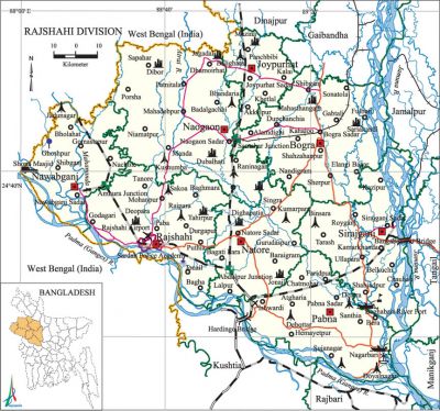
Rajshahi Division
Rajshahi Division area 17974.68 sq km, located in between 23°48' and 25°16' north latitudes and in between 88°01' and 89°48' east longitudes. It is bounded by west bengal state of India and dinajpur and gaibandha districts on the north, rajbari and kushtia districts on the south, jamalpur, tangail and manikganj districts on the east, West Bengal state of India on the west.
Population Total 18355554; male 9192588, female 9162966; Muslim 17129569, Hindu 1078323, Buddhist 559, Christian 69105 and others 77998.
Water bodies Main rivers: padma, jamuna, atrai, mahananda; chalan beel is notable.
Administration Rajshahi Town was established in the eighteenth century. Rajshahi Municipality was formed in 1876 and it was turned into a city corporation in 1991. On 25 January 1910 Rangpur was separated from Rajshahi Division to form a new Division.
| Division | ||||||||||
| Area (sq km) |
City corporation | District | Upazila | Paurasabha | Union | Ward | Population | Density (per sq km) |
Literacy rate (%) | |
| Urban | Rural | |||||||||
| 17974.68 | 1 | 8 | 66 | 58 | 557 | 546 | 3306756 | 15048798 | 1021 | 48.0 |
| District | |||||||||||
|
Name of District |
Area |
Upazila |
Municipality |
Ward |
Mahall |
Union |
Mouza |
Village |
Population |
Density |
Literacy rate (%) |
| Joypurhat | 1012.41 | 5 | 4 | 36 | 111 | 32 | 636 | 887 | 913768 | 903 | 57.5 |
| Naogaon | 3435.65 | 11 | 3 | 27 | 92 | 99 | 2497 | 2,780 | 2600157 | 757 | 48.2 |
| Nawabganj | 1702.55 | 5 | 4 | 45 | 156 | 45 | 736 | 1135 | 1647521 | 968 | 42.9 |
| Natore | 1721.84 | 6 | 7 | 75 | 166 | 47 | 1075 | 1260 | 1577369 | 898 | 49.6 |
| Pabna | 2376.13 | 9 | 9 | 87 | 234 | 73 | 1187 | 1,562 | 2523179 | 1012 | 46.7 |
| Bogra | 2898.68 | 12 | 11 | 111 | 360 | 108 | 1672 | 2,618 | 3400874 | 1173 | 49.4 |
| Rajshahi | 2425.37 | 13 | 14 | 126 | 306 | 71 | 1481 | 1,730 | 2595197 | 1070 | 53.0 |
| Sirajganj | 2402.05 | 9 | 6 | 60 | 160 | 82 | 1379 | 2,016 | 3097489 | 1290 | 42.1 |
Source Bangladesh Population Census 2011,Bangladesh Bureau of Statistics.

Religious institutions 'Mosque 44945, temple 4123, church 209, tomb 769, sacred place 43.
Literacy rate and educational institutions Average literacy 48.0%; male 50.5%, female 45.6%. Educational institutions: university 3, medical college 2, college 450, law college 7, agriculture college 1, teachers training college 17, polytechnic institute 5, sericulture research and training centre, homeopathic college 9, police academy 1, primary teachers training institute 1, institute of health technology 1, survey institute 1, nursing institute 1, secondary vocational school 26, secondary school 10123, primary school 13415, madrasa 5013. Noted educational institutions: rajshahi university (1953), Rajshahi University of Engineering and Technology (2003), Pabna Science and Technology University (2008), Rajshahi Medical College (1962), Shaheed Ziaur Rahman Medical College, Azizul Haque College (Bogra), Edward College (Pabna), Rajshahi College (1873), Sirajganj Government University College (1940), Joypurhat Government College (1946), Nawabganj Government college (1955), Naogaon Government College (1962), Ishwardi Government College (1963), Rajshahi Cadet college (1966), Nawabganj Government Mohila college (1966),' Joypurhat Government Mohila College (1972), Joypurhat Mohila Cadet College (2006), Pabna Polytechnic Institute (1891), Rajshahi Collegiate School (1828), Rajshahi Multilateral Girls' High School (1926), Rajshahi BB Academy (1898), Pabna Zila School (1853).
Main sources of income Agriculture 60.36%, non-agricultural labourer 3.38%, industry 3.99%, commerce 13.71%, transport and communication 3.52%, service 6.15%, construction 1.98%, religious service 0.16%, rent and remittance 0.43% and others 6.32%.
Health centres Hospital 20, TB hospital 9, infectious diseases hospital 11, diabetic hospital 10, heart foundation 1, maternity and child welfare centre 27, police hospital 7, railway hospital 5, eye hospital 7, mission hospital 4, satellite clinic 251, mental hospital 1, nursing institute 37, upazila health complex 120, health and family welfare centre 690, clinic 100. [Sajahan Miah]
References Bangladesh Population Census 2001 and 2011, Bangladesh Bureau of Statistics; Cultural survey report of zilas and upazilas of Rajshahi Division 2007.
