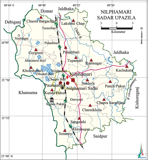
Nilphamari Sadar Upazila
Nilphamari Sadar Upazila (nilphamari district) area 373.09 sq km, located in between 25°48' and 26°03' north latitudes and in between 88°44' and 88°59' east longitudes. It is bounded by domar and jaldhaka upazilas on the north, saidpur upazila on the south, kishoreganj (Nilphamari Sadar Upazila|Nilphamari) and Jaldhaka upazilas on the east, khansama and debiganj upazilas on the west.
Population Total 3718790; male 191336, female 180543; Muslim 293509, Hindu 77740, Buddhist 344, Christian 15 and others 271.
Water bodies Main rivers: Jamuneshwari, Chikli; Motiatura Beel, Dhuliar Beel, Choura Beel are notable.
Administration Nilphamari Thana was formed in 1870 and it was turned into an upazila in 1984.
| Upazila | ||||||||
| Municipality | Union | Mouza | Village | Population | Density (per sq km) | Literacy rate (%) | ||
| Urban | Rural | Urban | Rural | |||||
| 1 | 15 | 109 | 108 | 40084 | 331795 | 997 | 60.7 | 36.5 |
| Municipality | ||||||||
| Area (sq km) | Ward | Mahalla | Population | Density (per sq km) | Literacy rate (%) | |||
| 19.28 | 9 | 13 | 40084 | 2079 | 60.7 | |||
| Union | ||||||||
| Name of union and GO code | Area (acre) | Population | Literacy rate (%) | |||||
| Male | Female | |||||||
| Itakhola 31 | 5520 | 12094 | 11137 | 38.99 | ||||
| Kachukata 37 | 5247 | 11281 | 10634 | 39.52 | ||||
| Kunda Pukur 50 | 6789 | 14026 | 13198 | 39.42 | ||||
| Khokshabari 44 | 6451 | 10678 | 10207 | 36.59 | ||||
| Gorgram 25 | 6767 | 12555 | 11456 | 32.54 | ||||
| Chaora Bargachha 18 | 7560 | 11038 | 10650 | 34.43 | ||||
| Charaikhola 12 | 5903 | 14102 | 13198 | 36.25 | ||||
| Chapra Saramjani 11 | 5698 | 11679 | 11226 | 31.44 | ||||
| Tupamari 94 | 5198 | 12610 | 11779 | 37.82 | ||||
| Panch Pukur 63 | 4524 | 10231 | 9481 | 35.83 | ||||
| Palashbari 69 | 5617 | 9219 | 8871 | 36.06 | ||||
| Ramnagar 75 | 5179 | 10489 | 9994 | 30.73 | ||||
| Lakshmi Chap 73 | 5540 | 8263 | 8088 | 39.68 | ||||
| Sangalshi 82 | 4921 | 9440 | 8779 | 37.28 | ||||
| Sonaroy 88 | 6452 | 13205 | 12187 | 39.73 | ||||
Source Bangladesh Population Census 2001, Bangladesh Bureau of Statistics.
Archaeological heritage and relics nilsagar Dighi (former name Birat Dighi or Binni Dighi) at Gorgram, Tomb of Hazrat Pir Mohiuddin (Kunda Pukur), Bishnu Mandir (Palashbari).

History of the War of Liberation On 7 April 1971, the freedom fighters captured 300 rifles and 10,000 ammunitions from the armoury. On 8 April the Pak army took control over Nilphamari town.
Marks of the War of Liberation Memorial monument 2 (Swadhinatar Smriti Amlan, Bashar Gate).
Religious institutions Mosque 624, temple 371, church 1, tomb 2. Noted religious institutions: tomb of Hazrat Pir Mohiuddin (Kunda Pukur), tomb of Syed Pagla Pir (Darowani).
Literacy rate and educational institutions Average literacy 39.2%; male 45.6%, female 32.5%. Educational institutions: college 6, primary teachers training institute (PTI) 1, secondary school 87, primary school 217, madrasa 45, maktab 460. Noted educational institutions: Masiur Rahaman College (1958), Government Mohila College (1972), Nilphamari Government College (1986), Nilphamari Government High School (1882), Government Boys' High School (1914), Government Girls' High School (1945), Samir Uddin Boys'; High School (1963), Natun Bazar Bilateral High School (1970), Rabeya Balika Bidya Niketon (1973).
Newspapers and periodicals Daily: Nil Kantha; weekly: Nilphamari Barta, Nilsagar, Nilsamachar; defunct: Jagari (1962), Nilanchan (1972).
Cultural organisations Library 2, club 5, theatre group 4, theatre stage 1, music academy 4, cinema hall 2, women's organisation 1.
Main sources of income Agriculture 69.10%, non-agricultural labourer 3.41%, commerce 12.02%, transport and communication 3.39%, service 5.93%, construction 0.95%, religious service 0.21%, rent and remittance 0.12% and others 4.87%.
Ownership of agricultural land Landowner 55.02%, landless 44.98%; agricultural landowner: urban 40.41% and rural 56.70%.
Main crops Paddy, wheat, jute, potato, tobacco, cotton, ginger.
Extinct or nearly extinct crops Linseed, sesame, kaun, mustard, aus paddy.
Main fruits Mango, jackfruit, blackberry, guava, banana.
Communication facilities Pucca road 83 km, semi-pucca road 29 km, mud road 596.81 km; railway 25.6 km.
Extinct or nearly extinct traditional transport Palanquin, bullock cart.
Noted manufactories Textile mill, saw mill, rice mill, ice cream factory.
Cottage industries Goldsmith, blacksmith, weaving, potteries, bamboo work, wood work, tailoring, bidi factory.
Hats, bazars and fairs Hats and bazars are 26, fair 1, most noted of which are Bhabaniganj Hat, Babrijhar Hat, Darowani Hat, Dhelapir Hat, Pancha Pukur Hat, Palashbari Hat, Porardanga Hat, Jadur Hat, Shakhamacha Hat, Syed Pagla Pir Mela at Darwoani.
Main exports Paddy, jute, cotton, ginger, tobacco.
Access to electricity All the wards and unions of the upazila are under rural electrification net-work. However 12.37% of the dwelling households have access to electricity.
Sources of drinking water Tube-well 90.27%, tap 0.43%, pond 0.21% and others 9.09%.
Sanitation 14.12% (rural 9.39% and urban 55.42%) of dwelling households of the upazila use sanitary latrines and 19.75% (rural 19.77% and urban 19.65%) of dwelling households use non-sanitary latrines; 66.13% of households do not have latrine facilities.
Health centres District sadar hospital 1, TB hospital 1, diabetic hospital 1, satellite clinic 2, leprosy hospital 2, union health and family welfare centre 2, family planning centre 15, veterinary hospital 2.
NGO activities Operationally important NGOs are brac,asa, CARE, Nijera Kori, RDSS. [Abdus Sattar]
References Bangladesh Population Census 2001, Bangladesh Bureau of Statistics; Cultural survey report of Nilphamari Sadar Upazila 2007.
