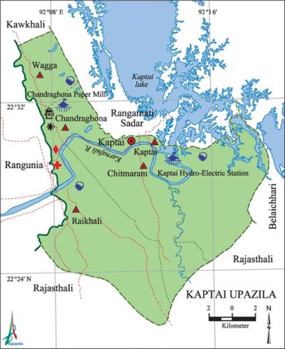
Kaptai Upazila
Kaptai Upazila (rangamati district) area 258.99 sq km, located in between 22°21' and 22°35' north latitudes and in between 92°05' and 92°18' east longitudes. It is bounded by rangamati sadar and kawkhali upazilas on the north, rajasthali upazila on the south, belaichhari on the east, rangunia and Kawkhali upazilas on the west.
Population Total 59693; male 31798, female 27895; Muslim 30604, Hindu 3626, Buddhist 24969, Christian 452 and others 42. Indigenous communities such as chakma, marma, Tanchanga and tripura belong to this upazila.
Water bodies Main river: karnafuli;' kaptai lake is notable.
Administration Kaptai Thana was formed in 1966 and it was turned into an upazila on 7 November 1983.
| Upazila | ||||||||
| Municipality | Union | Mouza | Village | Population | Density (per sq km) | Literacy rate (%) | ||
| Urban | Rural | Urban | Rural | |||||
| - | 5 | 10 | 148 | 14474 | 45219 | 230 | 69.8 | 56.8 |
| Upazila Town | ||||||||
|
Area (sq km) |
Mouza |
Population |
Density |
Literacy rate | ||||
| 40.15 | 1 | 14474 | 360 | 69.8 | ||||
| Union | ||||
| Name of union and GO code | Area (acre) | Population | Literacy rate (%) | |
| Male | Female | |||
| Wagga 86 | 7066 | 4801 | 4369 | 57.5 |
| Kaptai 57 | 19782 | 9443 | 7195 | 64.3 |
| Chandraghona 19 | 4992 | 6604 | 5563 | 77.1 |
| Chitmaram 38 | 14874 | 2621 | 2512 | 49.4 |
| Raikhali 76 | 20806 | 8329 | 8256 | 47.0 |
Source Bangladesh Population Census 2011, Bangladesh Bureau of Statistics.
War of Liberation The employees of the Kaptai hydroelectricity plant and local students together formed a committee for resistance against the Pak army in Kaptai upazila at the very beginning of the War of Liberation. However, the Pakistani soldiers could occupy Kaptai following which they started torturing the local people, looting houses and also setting fire on them. Freedom fighters did not have much strength to face the enemies but still they could successfully carry out guerilla operations at a few places of the upazila.
For details: see কাপ্তাই উপজেলা, বাংলাদেশ মুক্তিযুদ্ধ জ্ঞানকোষ (Encyclopedia of Bangladesh War of Liberation), বাংলাদেশ এশিয়াটিক সোসাইটি, ঢাকা ২০২০, খণ্ড ২।
Literacy rate and educational institutions Average literacy 60.0%; male 65.6%, female 53.5%. Educational institutions: college 1, secondary school 5, vocational educational institution 1, primary school 100.
Main sources of income Agriculture 32.02%, non-agricultural labourer 8.14%, commerce 11.87%, transport and communication 2.13%, service 36.83%, construction 1.08%, religious service 0.20%, rent and remittance 0.46% and others 7.27%.

Ownership of agricultural land Landowner 56.55%, landless 43.45%; agricultural landowner: urban 63.39% and rural 43.52%.'
Main crops Paddy, hilly potato, cotton, ginger, vegetables.
Main fruits Jackfruit, banana, lemon, coconut, pineapple.
Communication facilities Pucca road 80 km, semi-pucca road 31 km, mud road 151 km; waterway 35 km.
Noted manufactories Chandraghona Paper Mill, Rayon Industry, Kaptai Hydro-Electric Project, engineering workshop, steel mill.
Cottage industries Goldsmith, weaving, blacksmith, bamboo work, cane work, wood work.
Tourist spots Kaptai National Park, Kaptai Lake, Chhit Murong Pagoda.
Main exports Banana, electricity, cotton, ginger, jackfruit, bamboo and cane products.
Access to electricity All the unions of the upazila are under rural electrification net-work. However 63.0% of the dwelling households have access to electricity.
Sources of drinking water Tube-well 31.8%, tap 29.7% and others 38.5%.
Sanitation 59.0% of dwelling households of the upazila use sanitary latrines and 27.5% of dwelling households use non-sanitary latrines; 13.5% of households do not have latrine facilities.
Health centres Hospital 8, satellite clinic 2, upazila health complex 1, family planning centre 1.
NGO activities Operationally important NGOs are asa, 'proshika, CDF, CHCP, IDF, Hill Vission, Epsha. [Atikur Rahman]
References Bangladesh Population Census 2001 and 2011, Bangladesh Bureau of Statistics; Cultural survey report of Kaptai Upazila 2007.
