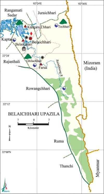
Belaichhari Upazila
Belaichhari Upazila (rangamati district) area 745.91 sq km, located in between 21°54' and 22°33' north latitudes and in between 92°17' and 92°36' east longitudes. It is bounded by juraichhari and rangamati sadar upazilas on the north, ruma and thanchi upazilas on the south, Mizoram (India) and Myanmar on the east, kaptai, rajasthali and rowangchhari upazilas on the west.
Population Total 28525; male 15174, female 13351; Muslim 3074, Hindu 467, Buddhist 22095, Christian 2796 and others 93. Indigenous communities such as chakma, marma, tanchangya, tripura, bawm, pankho, chak, Riang Khumi and Mro belong to this upazila.
Water bodies Main river: Rainkhiang.
Administration Belaichhari Thana was formed in 1976 and it was turned into an upazila in 1983.
| Upazila | ||||||||
| Municipality | Union | Mouza | Village | Population | Density (per sq km) | Literacy rate (%) | ||
| Urban | Rural | Urban | Rural | |||||
| - | 3 | 9 | 59 | 2458 | 26067 | 38 | 66.7 | 29.2 |
| Upazila Town | ||||||||
|
Area
|
Mouza |
Population |
Density |
Literacy rate (%) | ||||
| 10.36 | 1 | 2458 | 237 | 66.7 | ||||
| Union | ||||||||
| Name of union and GO code | Area (acre) | Population | Literacy rate (%) | |||||
| Male | Female | |||||||
| Kangara Chhari 71 | 25600 | 2945 | 2832 | 43.1 | ||||
| Farua 47 | 137600 | 7446 | 6729 | 17.1 | ||||
| Belaichhari 23 | 21120 | 4783 | 3790 | 50.3 | ||||
Source Bangladesh Population Census 2011, Bangladesh Bureau of Statistics.

Historical events Once tribal insurgencies were regular features in this upazila.
War of Liberation After the defeat of Pak army in an encounter in mid-1971, about 2000 tribal razakars joined hands with the rebel Mizos of the tribal area. Manabendra Narayan Larma became their leader and formed the shanti bahini. To control Shanti Bahini, Farua Police Station was established covering the boarding areas. Later on Shanti Bahini and the Jana Sanghati Samity shifted their main camp to Tripura, as a result of which the police station ant Farua lost significance and it was merged with the Belaichhari Thana. About 30 thousand people were killed in encounters with the Shanti Bahini.
For details: see বিলাইছড়ি উপজেলা, বাংলাদেশ মুক্তিযুদ্ধ জ্ঞানকোষ (Encyclopedia of Bangladesh War of Liberation), বাংলাদেশ এশিয়াটিক সোসাইটি, ঢাকা ২০২০, খণ্ড ৭।
Religious institutions Mosque 16, temple 2, buddhist temple 33, church 5.
Literacy and educational institutions Average literacy 32.8%; male 41.6%, female 22.5%. Educational institutions: secondary school 2, primary school 2, madrasa 1.
Main sources of income Agriculture 73.79%, non-agricultural labourer 2.92%, commerce 9.29%, service 5.82%, construction 0.44%, religious service 0.20%, rent and remittance 0.22% and others 7.32%.
Ownership of agricultural land Landowner 56.02%, landless 43.98%; agricultural landowner: urban 28.30% and rural 58.79%.
Main crops Paddy, hilly potato, cotton, ginger.
Main fruits Jackfruit, banana, pineapple.
Fisheries, dairies and poultries This upazila has a number of fisheries, dairies and poultries.'
Communication facilities Pucca road 9.61 km, mud road 557.59 km (Census 2001).
Cottage industries Goldsmith, blacksmith, weaving, bamboo work, cane work.
Noted Hats, bazars and fairs Belaichhari Sadar Bazar, Farua Bazar, Kangara Chhari Bazar.
Main exports Banana, cotton, ginger, jackfruit, wood, bamboo and cane products.
Access to electricity All the unions of the upazila are under rural electrification net-work. However 24.5% dwellings have access to electricity.
Sources of drinking water Tube-well 28.4%, tap 1.6% and others 70.0%.
Sanitation 18.6% of dwelling households of the upazila use sanitary latrines and 42.9% of dwelling houses use non-sanitary latrines; 38.5% of households do not have latrine facilities.
Health centres Upazila health complex 1. [Atikur Rahman]
References Bangladesh Population Census 2001 and 2011, Bangladesh Bureau of Statistics; Cultural survey report of Belaichhari Upazila 2007.
