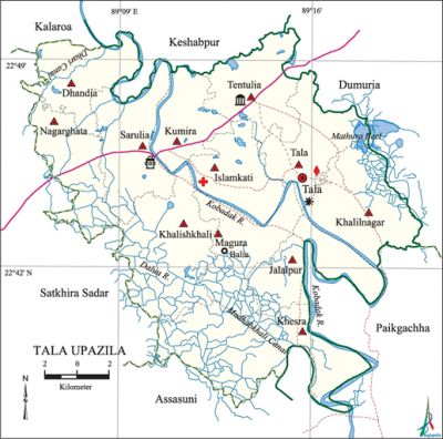
Tala Upazila
Tala Upazila (satkhira district) area 337.24 sq km, located in between 22°32' and 22°50' north latitudes and in between 89°05' and 89°20' east longitudes. It is bounded by kalaroa, keshabpur and dumuria upazilas on the north, assasuni upazila on the south, Dumuria and paikgachha upazilas on the east, satkhira sadar upazila on the west.
Population Total 299820; male 149389, female 150431; Muslim 220240, Hindu 77231, Buddhist 3, Christian 1859 and others 487.
Water bodies Main rivers: kobadak, Dalua; Madhabkhali Canal, Dhari Canal and Mathura' Beel is notable.
Administration Tala Thana was formed in 1913 and it was turned into an upazila in 1989.
| Upazila | ||||||||
| Municipality | Union | Mouza | Village | Population | Density (per sq km) | Literacy rate (%) | ||
| Urban | Rural | Urban | Rural | |||||
| - | 12 | 151 | 229 | 9528 | 290292 | 889 | 68.2 | 50.3 |
| Upazila Town | |||||
|
Area (sq km) |
Mouza |
Population
|
Density (per sq km)
|
Literacy rate (%) | |
| 6.60 | 4 | 9528 | 1444 | 68.2 | |
| Union | ||||
| Name of union and GO code | Area (acre) | Population | Literacy rate (%) | |
| Male | Female | |||
| Islamkati 15 | 5304 | 9878 | 10010 | 56.2 |
| Kumira 55 | 4688 | 11898 | 12101 | 48.2 |
| Khalilnagar 31 | 7947 | 14154 | 14274 | 47.5 |
| Khalishkhali 39 | 9484 | 12965 | 12844 | 51.1 |
| Khesra 47 | 11748 | 12531 | 12778 | 52.5 |
| Jalalpur 23 | 5923 | 10778 | 10921 | 50.6 |
| Tala 87 | 6113 | 16332 | 16695 | 53.7 |
| Tentulia 94 | 6542 | 12165 | 12842 | 44.3 |
| Dhandia 07 | 5795 | 10585 | 10287 | 45.2 |
| Nagarghata 71 | 6229 | 9286 | 8972 | 54.7 |
| Magura 63 | 6812 | 10306 | 10253 | 53.9 |
| Sarulia 79 | 6749 | 18511 | 18454 | 52.8 |
Source Bangladesh Population Census 2011, Bangladesh Bureau of Statistics.

Archaeological heritage and relics Tentulia Jami Mosque.
Historical events The anushilan samiti was formed in 1902 with the initiatives of Gyanendranath Basu, Sree Aurobindo and Promathnath Mitra. In 1905 intensive movement began under Raj Kumar Basu against the annulment of the partition of bengal. On 16 August 1909 the Anushilan Samiti, under its Secretary Shachin Mitra, conducted a robbery at the residence of Mathur Poddar of village Nangla under this upazila. A peasant conference was held under the chairmanship of peasant leader Sudha Roy in 1944 at the playground of Kumira High School.
War of Liberation Freedom fighters had encounters with the Pak army and their collaborators at three places: Barat, Baliadaha and Magura. Besides, the freedom fighters had attacked a launch by which the Pakistani soldiers were carrying food and killed two razakars.
For details: see তালা উপজেলা, বাংলাদেশ মুক্তিযুদ্ধ জ্ঞানকোষ (Encyclopedia of Bangladesh War of Liberation), বাংলাদেশ এশিয়াটিক সোসাইটি, ঢাকা ২০২০, খণ্ড ৪।
Religious institutions Tentulia Jami Mosque is most notable.
Literacy rate and educational institutions Average literacy 50.9%; male 55.3%, female 46.5%. Educational institutions: college 12, secondary school 60, primary school 119, madrasa 21. Noted educational institutions: Tala Government College (1969), Kumira Mohila Degree College (1993), Baliadaha KMMC Institution (1899), Tala B Dey Government High School (1888), Kumira Multilateral High School (1902), KMMC Secondary High School, Dhandia Union Institution (1915), Khalishkhali Shaiva Girls' Secondary School (1928), Islamkati Girls' Secondary School (1929), Patkelghata Qaumi' Madrasa (1960).
Cultural organisations Library 16, club 60, cinema hall 3, theatre stage 1, theatre group 1, women's organisation 71.
Main sources of income Agriculture 70.34%, non-agricultural laborer 2.67%, industry 1.30%, commerce 13.17%, transport and communication 3.02%, service 4.21%, construction 0.85%, religious service 0.25%, rent and remittance 0.15% and others 4.04%.
Ownership of agricultural land Landowner 65.80%, landless 34.20%; agricultural landowner: urban 65.84% and rural 65.80%.
Main crops Paddy, wheat, jute, mustard, potato, gram, onion, lentil, turmeric, vegetables.
Extinct or nearly extinct crops Tobacco, linseed, kaun, coriander.
Main fruits Mango, jackfruit, coconut, betel nut, litchi, papaya, plum, guava, banana, blackberry.
Communication facilities Pucca road 150 km, semi-pucca road 75 km, mud road 595 km.
Extinct or nearly extinct traditional transport Palanquin, horse carriage, bullock cart.
Noted manufactories Rice mill, oil mill.
Cottage industries Goldsmith, blacksmith, potteries, weaving, handicraft, mat work, reeds work.
Hats, bazars and fairs Hats and bazars are 12, fairs 4, most noted of which are Patkelghata Hat, Khalishkhali Hat, Dalua Hat, Tala Hat, Jethua Hat, Jatpur Hat, Kumira Hat, Magura Hat, Melekbari Hat, Balia Hat, Kathipara Hat and seven day long Durga Puja Mela.
Main exports Paddy, jute, wheat, potato.
Access to electricity All the unions of the upazila are under rural electrification net-work. However 43.0% of the dwelling households have access to electricity.
Sources of drinking water Tube-well 95.1%, tap 0.7% and others 4.2%.
Sanitation 48.2% of dwelling households of the upazila use sanitary latrines and 47.3% of dwelling households use non-sanitary latrines; 4.5% of households do not have latrine facilities.
Health centres Upazila health complex 1, union family welfare centre 32, community clinic 36, clinic 4, charitable dispensary 2.
NGO activities Operationally important NGOs are brac, asa. [Ashraful Islam Goldar]
References Bangladesh Population Census 2001 and 2011, Bangladesh Bureau of Statistics; Cultural survey report of Tala Upazila 2007.
