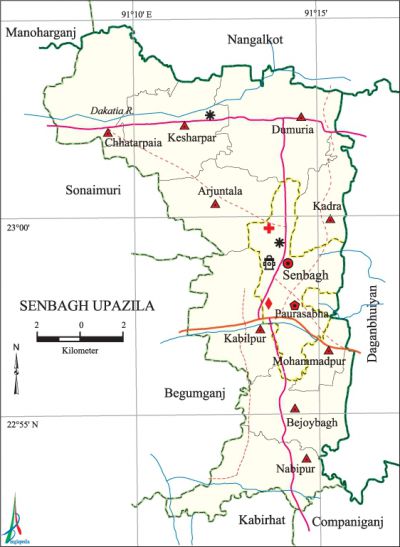
Senbagh Upazila
Senbagh Upazila (noakhali district) area 159.36 sq km, located in between 22°52' and 23°05' north latitudes and in between 91°08' and 92°16' east longitudes. It is bounded by nangalkot and manoharganj upazilas on the north, kabirhat and companiganj (Noakhali) upazilas on the south, daganbhuiyan upazila on the east, begumganj and sonaimuri upazilas on the west.
Population Total 282894; male 133341, female 149553; Muslim 271810, Hindu 10969, Buddhist 106, Christian 6 and others 3.
Water bodies Main river: dakatia.
Administration Senbagh Thana was turned into an upazila in 1983.
| Upazila | ||||||||
| Municipality | Union | Mouza | Village | Population | Density (per sq km) | Literacy rate (%) | ||
| Urban | Rural | Urban | Rural | |||||
| 1 | 9 | 97 | 105 | 26807 | 256087 | 1775 | 61.16 (2001) | 56.1 |
| Municipality | ||||||||
| Area (sq km) |
Ward | Mahalla | Population | Density (per sq km) |
Literacy rate (%) | |||
| - | 9 | 15 | 19065 | - | 63.6 | |||
| Upazila Town | ||||||||
|
Area (sq km) |
Mouza |
Population |
Density (per sq km) |
Literacy rate (%) | ||||
| 27.45 (2001) | 2 | 7742 | 1957 (2001) | 58.8 | ||||
| Union | ||||||||
| Name of union and GO code | Area (acre) | Population | Literacy rate (%) | |||||
| Male | Female | |||||||
| Arjuntala 13 | 3748 | 9061 | 11584 | 53.0 | ||||
| Kadra 57 | 3657 | 10710 | 13320 | 54.8 | ||||
| Kabilpur 47 | 4879 | 18717 | 20455 | 58.1 | ||||
| Kesharpar 66 | 4595 | 17972 | 18949 | 57.4 | ||||
| Chhatarpaia 28 | 4225 | 17377 | 17289 | 56.3 | ||||
| Dumuria 38 | 5534 | 13917 | 16798 | 52.4 | ||||
| Nabipur 85 | 4204 | 13346 | 15759 | 54.7 | ||||
| Bejoybagh 19 | 3608 | 11979 | 13173 | 58.9 | ||||
| Mohammadpur 76 | 2950 | 11125 | 12298 | 58.6 | ||||
Source Bangladesh Population Census 2001 and 2011, Bangladesh Bureau of Statistics.

Archaeological heritage and relics Fort at Kadra, Statue of a hero at Beer Kot, Mosque of Kusha Gazi.
War of Liberation A training camp for the freedom fighters was established at Kanrihat of the upazila during the war of liberation. An encounter was held when the freedom fighters raided the Pak military camp at Domnakandi Primary School in which a number of freedom fighters were killed.
For details: see সেনবাগ উপজেলা, বাংলাদেশ মুক্তিযুদ্ধ জ্ঞানকোষ (Encyclopedia of Bangladesh War of Liberation), বাংলাদেশ এশিয়াটিক সোসাইটি, ঢাকা ২০২০, খণ্ড ১০।
Religious institutions Mosque 360, temple 39, tomb 10. Noted religious institutions: Senbagh Bazar Jami Mosque.
Literacy rate and educational institutions Average literacy 56.7%; male 56.3%, female 57.0%. Educational institutions: college 3, secondary school 26, community school 7, primary school 124, madrasa 25. Noted educational institutions: Mohammadpur Ramendra Model High School (1916), Bejoybagh Nabakrishna High School (1939), Senbagh Government Pilot High School (1940), Senbagh Adarsha Government Primary School (1940), Joynagar Wazedia Alim Madrasa (1900), Chhamir Munshirhat Dakhil Madrasa (1902), Kadra Hamidia Dakhil Madrasa (1919).
Newspapers and periodicals Monthly: Senbagh Barta, Senbagh Samachar.
Cultural organisations Library 7, club 17, cinema hall 1, playground 14.
Tourist spots Dighi of Bhuiyan.
Main sources of income Agriculture 31.45%, non-agricultural labourer 2.39%, industry 0.68%, commerce 14.94%, transport and communication 4.37%, service 21.48%, construction 1.25%, religious service 0.50%, rent and remittance 10.82% and others 12.12%.
Ownership of agricultural land Landowner 64.26%, landless 35.74%; agricultural landowner: urban 65.87% and rural 63.86%.
Main crops Paddy, wheat, betel leaf, vegetables.
Extinct or nearly extinct crops Sesame, linseed, mustard, sweet potato, aus paddy.
Main fruits Mango, jackfruit, banana, papaya, coconut, date, betel nut.
Fisheries, dairies and poultries Poultry 16, nursery 23.
Communication facilities Pucca road 188.01 km, semi-pucca road 5.06 km, mud road 457.41 km; waterway 63 km.
Extinct or nearly extinct traditional transport Palanquin, horse carriage, bullock cart.
Noted manufactories Rice mill, flour mill, ice factory.
Cottage industries Goldsmith, blacksmith, potteries, palm leaf fan work, bamboo and cane work.
Hats, bazars and fairs Hats and bazars are 25, fairs 10, most noted of which are Senbagh Bazar, Kankir Hat, Chhamir Munshirhat, Darbesh Hat, Amtali Mela, Naldia Mela and mela of Panchpir Dargah.'
Main exports Paddy, banana, betel leaf, coconut, betel nut.
Access to electricity All the wards and unions of the upazila are under rural electrification net-work. However 73.6% of the dwelling households have access to electricity.
Sources of drinking water Tube-well 94.9%, tap 0.8% and others 4.3%. The presence of arsenic has been detected in shallow tube-well water of the upazila.
Sanitation 80.0% of dwelling households of the upazila use sanitary latrines and 17.2% of dwelling households use non-sanitary latrines; 2.8% of households do not have latrine facilities.
Health centres Upazila health complex 1, satellite clinic 2, mother and child welfare centre 1, clinic 12.
Natural disasters The cyclone of 16 October 1961 caused heavy damages to settlements, plantation and crops of the upazila.
NGO activities Operationally important NGOs are asa, brac, caritas, CARE, proshika. [Md. Tawhid Hussain Chowdhury]
References Bangladesh Population Census 2001 and 2011, Bangladesh Bureau of Statistics; Cultural survey report of Senbagh Upazila 2007.
